Data 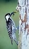
Download the RCW data linked on our ELC site. Copy the zipped file over to your working folder on the E:\ drive and unzip it. I converted the data to feature classes in a file geodatabase. We realized that there were inconsistencies with the original shapefiles (2/13/2020).
The attribute table of the CoverType feature class contains information about the forest vegetation and management history within each stand. This layer uses the projected coordinate system UTM/NAD83/Zone17N. We will be working with a subset of these fields, described in the metadata table below.
| Field Name (column titles) | Field Type | Description | Units |
| tloac | Number | GIS acreage | acres |
| type | String | Stand type classifier | Self-explanatory |
| baac | Number | Basal area per acre | ft2/acre |
| cuft | Number | Volume per acre | ft3/acre |
| age2018 | Number | Stand age, 2018 | years |
| totvol (must add) | Number | Total stand volume | ft3 |
| origin | String | Denotes planted or natural pine origin |
The DetailedRivers feature class is self-explanatory. It contains detailed rivers of the area. This layer uses the geographic coordinate system, WGS84.
The CommunityRCWSitings.csv layer is a list of 30 locations on the forest where individuals think they have spotted an active RCW nest. The lat/lon coordinates use the geographic coordinate system, WGS84.
ArcGIS Prep:
- load all three layers
- set your data frame coordinate system to UTM17N
- use the MAKE XY EVENT LAYER tool to plot your points
- recall that the coordinates in this file are in Lat/Long so you must define the coordinate system as Lat/Long in this tool’s dialog
- make sure you save it out to your working directory
- organize your layers so you can see the points sitting on the lines and both of them on the polygons
- symbolize your layers so you can differentiate features in each layer
- polygons light grey
- rivers thick(er) blue
- points bright red, large triangle
- save your project to your working directory
RCW Habitat
Your wildlife biologist is surveying for red-cockaded woodpeckers. You will use ArcMap to identify stands that have habitat structures that are most likely to support red-cockaded woodpeckers to narrow down the area you will search. To do this, you will use the select by attributes function in ArcMap.
(https://www.fs.usda.gov/Internet/FSE_DOCUMENTS/stelprdb5157146.pdf)
Generally, red-cockaded woodpeckers are more likely to be found in:
- Natural Evergreen Forests versus Planted Evergreen Forests
- Older forests stands
- Basal area between 40 and 70 ft2
- Larger patches of forest
To identify these areas within our landscape, go to the Selection main menu and use the select by attributes command to find stands that have:
- Type equals Evergreen Forest and,
- Origin equals Natural and,
- Age greater than 60 years and,
- Acres greater than 20 and,
- Basal area between 40ft2 and 70ft2 (include 40 and 70)
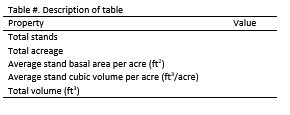
TASK 1: Report the number of stands, total acreage, average stand basal area per acre, average stand cubic volume per acre, and total volume. Round to the nearest tenth and match the table format to the example below.
You will end up with 217 total stands selected.
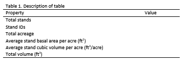
Refine your stand selection
To further refine our selection of stands, we need to know which ones are adjacent to a stream. Use a Select by Location to figure out which of those stands (the ones you selected above) intersect a stream (use a 5m search distance). You will end up with 89 total stands selected.
Task 2: Report your findings using the same table format.

One last refinement
The wildlife biologist has been inundated with reports from community scientists who believe they have spotted an active RCW nest. Compare the locations in the CommunityRCWSitings.csv list of possible sightings with the suitable stands near a river (these are the stands you selected in task 2).
Task 3: Generate one final table to report on those nests that fall within one of those stands.
Prepare your results in a Word document and upload it to the class’ Assignment Dropbox #5.