Output paths
Screen shots below show my project’s working directory: …/OcNF_Data/ . The directory contains:
- Five shapefiles, one raster, and one DBF table, and
- One file geodatabase, OcNF_Data.ddb that holds 5 (vector) feature classes, one raster, and one table
ArcMap Catalog listing:
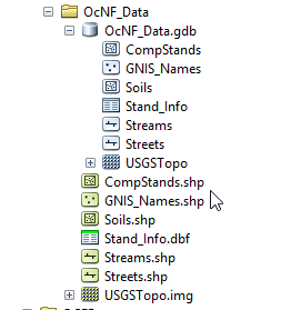
Windows File Explorer listing:

Where should you save SHAPEFILES, and where can’t you save them? This depends on your decision where to save your output. You should either save all your output vectors and rasters in a file geodatabase or you should save all of your output as a series of shapefiles and rasters.
If your choice is to save output to a file geodatabase:
- Drill down INTO the file geodatabase (the folder with a ‘.gdb’ extension)
- No file extension is necessary (you WILL receive an error if you try to append one)
If you decide to use a series of shapefiles and rasters:
- Drill down INTO your project folder (DO NOT enter the FGDB folder)
- Append the ‘.shp’ extension for a shapefile
- Append the ‘.img’ extension for a raster
- Append the ‘.dbf’ or ‘.csv’ extension for a table

Joining Table Examples:
- Join current Census summaries to county boundary shapefiles
- County boundaries are relatively static, yet census summaries change yearly
- Join updated stand information to stand boundaries
- These summaries are updated each quarter or year, so instead of having a stand shapefile for 2016, another one for 2017, and another one for 2018 (this turns into a data management nightmare), it is convenient to use the same stand boundaries and join these summaries as they change.
- Join plot-level timber cruise information to cruise plots
- Sometimes table joins are a convenience. It is a simple procedure to join the plot averages to the cruise plots to quickly view the distribution of basal areas or heights.
Join external tabular data
When joining an external table to a spatial layer in ArcGIS, you must…
- have a common field in the external table with values that match values in a field in the spatial layer
- have either a one-to-one relationship or a many-to-one relationship
- NOT have a one-to-many relationship
ONE-TO-ONE RELATIONSHIP
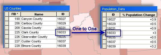
- One record in my county GIS layer matches one layer in the external population data file
MANY-TO-ONE RELATIONSHIP
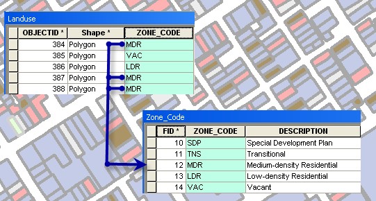
- Many records in my land cover GIS layer relate to one record in the external zone data file
You may NOT perform a ONE-TO-MANY join – can’t join many external records to one feature.