Short Intro to Satellite Remote Sensing
Important terms and topics
- Electromagnetic spectrum
- DN v. Radiance v. Reflectance
- Active/Passive sensor
- Spatial resolution
- Spectral resolution
- Temporal resolution
- Spectral signature
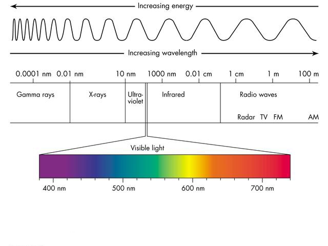
Electromagnetic Spectrum
Digital Number (DN) v. Radiance v. Reflectance (Good Description Here)
- DN: The digital number is the generic term for pixel values is Digital Number or DN. It is commonly used to describe pixel values that have not yet been calibrated into physically meaningful units. If you just want to look at an image, and don’t intend to interpret the pixel values in terms of some physically meaningful, quantitative value like radiance or reflectance (or any value derived from radiance or reflectance values, such as abundance), then it may be just fine to keep your image in its original DN values.
- Radiance: Radiance is the amount of radiation coming from an area. Radiance includes radiation reflected from the surface,bounced in from neighboring pixels, and reflected from clouds above the area of the pixel. Radiance is also affected by the source of the radiation, which for optical imagery is the sun.
- Reflectance: Reflectance is the proportion of the radiation striking a surface to the radiation reflected off of it. Some materials can be identified by their reflectance spectra, so it is common to correct an image to reflectance as a first step toward locating or identifying features in an image. Top of Atmosphere Reflectance (TOA) is the reflectance measured by a space-based sensor flying higher than the earth’s atmosphere. These reflectance values will include contributions from clouds and atmospheric aerosols and gases. Surface Reflectance is the reflectance of the surface of the Earth. Clouds and other atmospheric components do not affect surface reflectance spectra. Typically images of surface reflectance are derived from calibrated radiance images. There are many ways to derive reflectance images from radiance images, including model-based atmospheric corrections.
Passive v. Active Sensors
- Passive sensor energy source is the sun
- Active sensor energy source is the instrument itself
- Eyes are a passive sensor, bat’s echolocation nav system is an active sensor
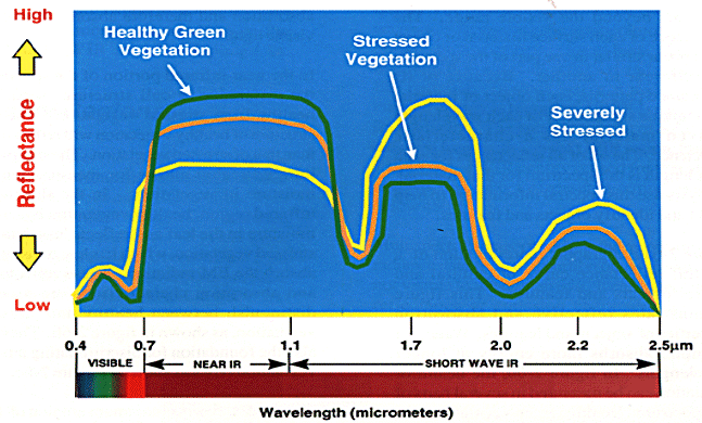
Abbreviated How We Leverage Satellite Imagery (Spectral Signatures)
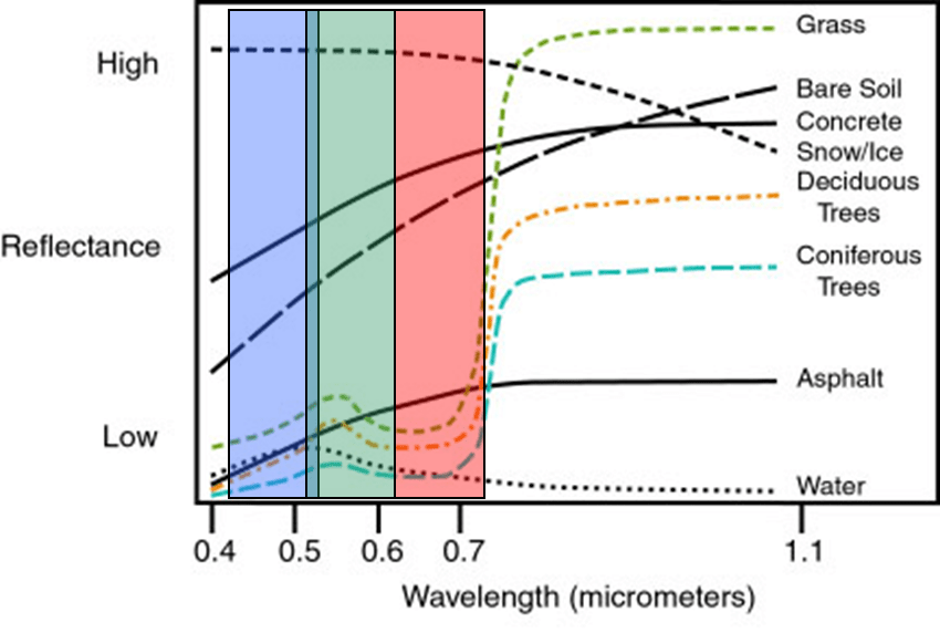
- Different ground cover absorbs and reflects different amounts of energy (light) – this varies across the electromagnetic spectrum
- Bare soil reflects a higher amount of energy than conifer and deciduous trees in the visible parts of the electromagnetic spectrum but less than snow and ice
- The amount of energy reflected by grass, Conifer, deciduous, and water are near-similar in the visible blue, green, and red parts of the spectrum, but the differences among these cover types diverge in the longer wavelength portion of the electromagnetic (area to the right of the red portion)
- The portion of the electromagnetic spectrum to the right of the RED band is called the NEAR-INFRARED (NIR) band
- The ratio of the NIR to red for grass is larger than for water – this is useful!!!
- The ratio of the red and green for concrete will be similar for asphalt – not useful!!!
Spectral v. Spatial v. Temporal Resolution
- Spectral resolution: the portion or portions of the electromagnetic spectrum recorded by the sensor; depends on the number of bands in the image and the width of each band
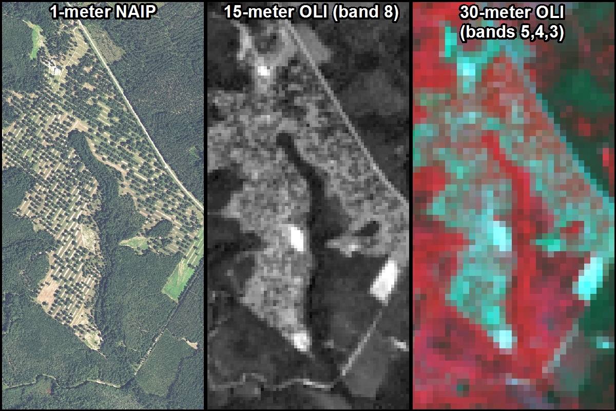
- Spatial resolution: the smallest ‘thing’ one can distinguish in the digital RS image
- Cell Size: the dimension of one side of one pixel in the image; reported in ground units (ie. NAIP is 1-meter, Landsat 8 is 30-meters)
- Temporal resolution: Repeat cycle of the sensor – the amount of time it takes the sensor to RE-capture information about the same area
Advantages of RS:
- Synoptic view of the landscape
- Sense portions of the spectrum not visible to the human eye (the near and thermal infrared)
- Repeat cycle
- Cost-effective means of augmenting (adding value) to field data collection missions
What can’t be done? Can’t see …
- everything (spectral limitations)
- at all times (temporal limitations)
- everywhere (spatial limitations)
- at any resolution (spatial limitations)
Examples of remote sensing
- Aerial photos (NAIP, Google Earth)
- IKONOS,
- Landsat
- Landsat 1 – 4 Multi-spectral sensor (MSS)
- Landsat 5 Thematic Mapper (TM)
- Landsat 7 Enhanced Thematic Mapper Plus (ETM+)
- Landsat 8 Operational Land Imager (OLI) and Thermal Infrared Sensor (TIRS)
- Landsat 9
- Sentinel-2
- Trip through time with Landsat 9
Landsat 8
- Improvements over previous platforms
- 12-bit dynamic range vs 8 bit (4096 potential greyscale values vs 256)
- 11-bands of spectral information
- Characteristics
- Multispectral OLI bands 1 – 7 and 9: 30 meter spatial resolution
- Panchromatic OLI band 8: 15 meter spatial resolution
- TIRS bands 10 and 11: acquired at spatial resolution of 100 meters but resampled down to 30 meters
Landsat Band Characteristics (http://landsat.usgs.gov/band_designations_landsat_satellites.php)
Landsat 8 Band Combinations (http://landsat.usgs.gov/L8_band_combos.php )
WRS-2: The Landsat ‘Path’ and ‘Row’ indexing method. A WRS-2 KML can be downloaded from https://landsat.usgs.gov/tools_wrs-2_shapefile.php – MAKE SURE YOU RETREIVE THE WRS-2 FILE.
Landsat 9
- Improvements over previous platforms
- 14-bit dynamic range vs 8 bit (4096 potential greyscale values vs 256)
- 11-bands of spectral information
- Landsat 9 Band information
- Landsat 9 Characteristics
EarthExplorer
Convenient way to acquire Landsat and Sentinel-2 data:
- earthexplorer.usgs.gov (Short Version: search, download, view, Viewing in ArcPro)