I went ahead and downloaded a couple Landsat images for us to work with just in case their site goes offline. Go ahead and download these and copy them over to this week’s working directory. Don’t worry about extracting them yet. Landsat 8 image and Landsat 7 image
Landsat data download
Search, download, and view Landsat satellite imagery in ArcPro: (Search, Download, View)
Locating the correct PATH and ROW
Landsat satellite imagery are index using the Worldwide Reference System (WRS). Imagery from the Landsat 4, 5, 7, and 8 sensors are indexed using WRS-2 (Landsat 1, 2, 3 follow WRS-1). The WRS 2 and 1 shapefiles can be downloaded from HERE – the ‘descending only’ boundaries are sufficient.
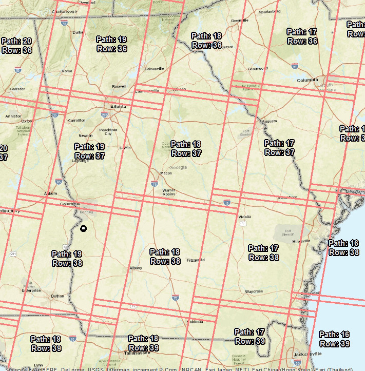
World Reference System 2 (WRS-2) Path/Row boundaries for Georgia. The Athens area is in both 18/36 and 18/37; Rome is in 20/36 and 19/36, and the Lab 7 property can be found in 19/38.
Image download from EarthExplorer
(Alternative method to EarthExplorer is LandsatLook)
The portal I use to download Landsat imagery is called EarthExplorer (earthexplorer.usgs.gov). You must register with the site before you can download data (https://youtu.be/p7CE6z4vnGw?t=2).
Search Criteria:
Begin your image search by entering an address or a Path/Row and then click the ‘Show’ button

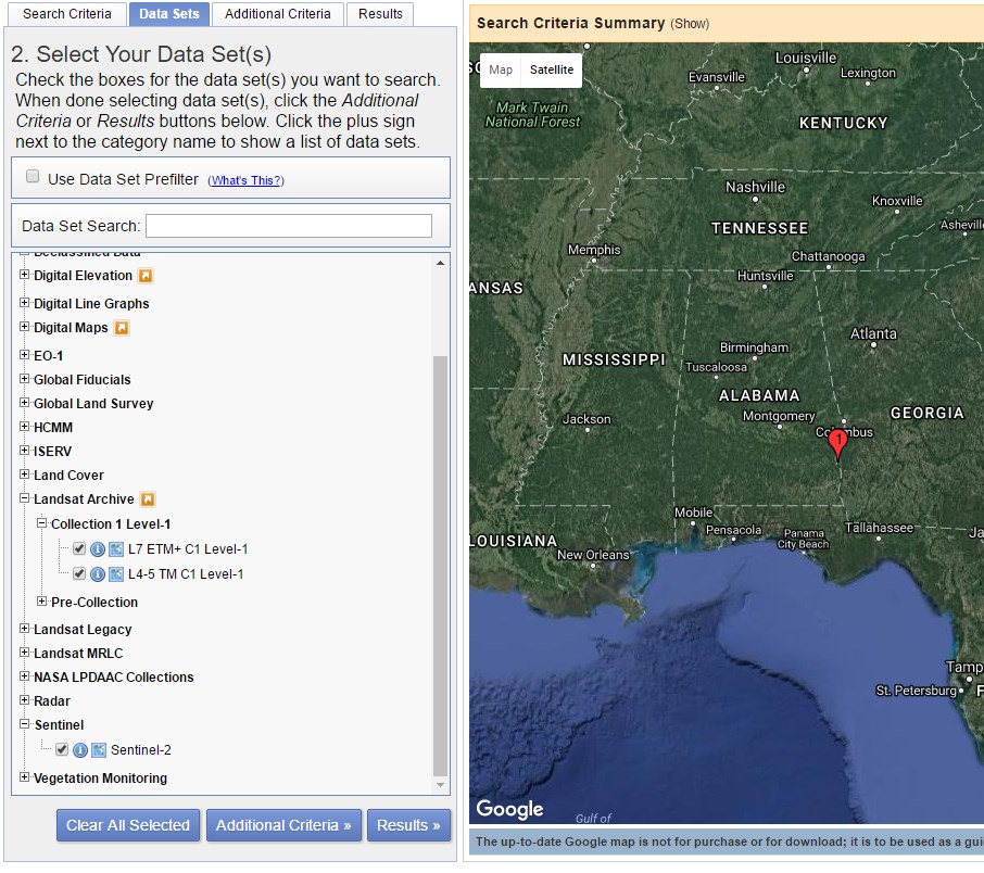
Data Sets:
Landsat 4, 5, and 7 selections are hidden under the ‘Landsat Archive’ option and Landsat 8 under the ‘Sentinel’ option. Landsat 8 selection, L8 OLI/TIRS, is found under the ‘Pre-Collection’ entry.
Results:
Click the ‘Results’ button at the bottom of the screen to see the available images for your site.
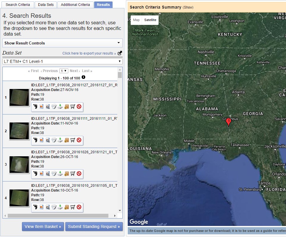
In the above screen shot, you are looking at the Landsat 7 results (indicated under Data Set on the left of the screen). The first entry was acquired on November 27, 2016. Click the download icon (![]() ) and then select the GeoTIFF product (
) and then select the GeoTIFF product (
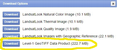
) to save the image to your working directory. If you are unsure which product to download, select the one whose file size is the largest.
Un-GZip and Un-Tar your data file
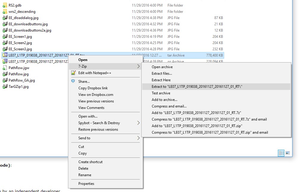
The files you download will be ‘Tarred and GZipped’. You must download a tool like 7Zip (you most likely want the 64-bit x64 version) to extract the data. You have to extract twice. The first uncompresses the TAR file and the second extracts the TAR file.
- In Windows Explorer, navigate to the …tar.gz file you downloaded, right-click on the .tar.gz >> 7-zip >> Extract Here

- You now have a new file with only a .tar extension. Extract the tar file to a new folder by right-click >> 7-Zip >> Extract to “….”
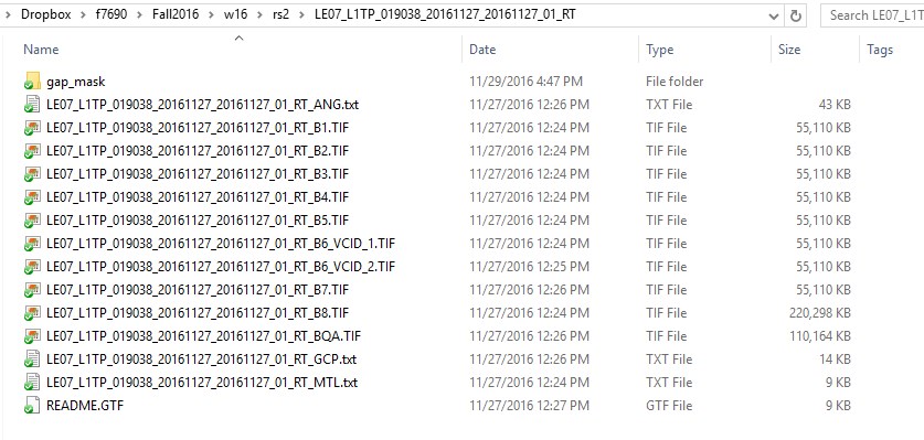
- You will find the TIF image files to load into ArcMap in the folder that was created in this last step (probably named something like “LE07_L1TP…20161127…”).
Load individual bands into ArcGIS
Load the individual TIF images as you would any GIS layer. The images will appear as black-and-white images. At this point, they’re supposed to look like that. The multispectral bands 1 – 5 and 7 have a 30-meter cell size and the panchromatic band 8 has a 15-meter cell size. The two thermal band images, bands 6, are acquired with a 100-meter cell size and resampled down to 30 meters.
Create multispectral image composite
Use the Composite Bands tool to create a multi-band image. Notice in the screen shot below that I have specified six individual bands (B1.TIF, B2.TIF, …, B5.TIF, and B7.TIF). In the new 6-band image, L7_27November2016_Multispectral.img, band1 will correspond with …B1.TIF, band2 will correspond with …B2.TIF, …, band6 will correspond with B7.TIF. The order in which you add the layers in this dialog does matter! 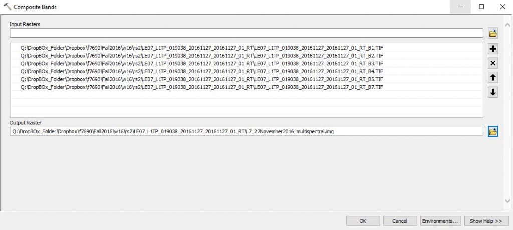
After this tool runs, load the image and test out some of these band combinations (right-click >> properties >> symbology)…
- color infrared: 4, 3, 2
- natural color: 3, 2, 1
- false color: 5, 4, 3, or 7, 5, 3, or 7, 4, 2
These band combinations will vary slightly for Landsat 8 imagery.
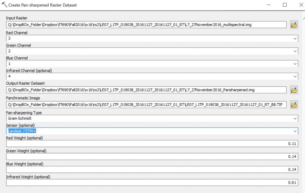
Create pansharpened image composite
The multispectral image you just created has a 30-meter cell size. Sometimes we want to combine the higher-resolution band 8 (15-meters) with the multispectral information in bands 1-5 and 7. The tool you use to do this is called Create Pan-sharpened Raster Dataset. The resulting image, L7_27November2016_Pansharpened.img, will have:
- 4 multispectral bands (original bands 1, 2, 3, 4)
- have a 15-meter cell size
Create NDVI image
In an effort to convert these images into actionable information, scientists have developed a series of vegetation indices. The normalized difference vegetation index, NDVI, is the most common. The NDVI formula is (Near Infrared band – RED band) / (Near Infrared band + RED band). In terms of the original image you downloaded, the formula is (…B4.TIF – …B3.TIF) / (…B4.TIF + …B3.TIF). These formulas can be applied using the Spatial Analyst’s Raster Calculator (ArcToolbox >> Spatial Analyst Tools >> Map Algebra >> Raster Calculator). You must have the Spatial Analyst loaded to do this.
First, load the original …B4.TIF and …B3.TIF layers. Next, open the Raster Calculator and type the following:
Float("LE07_L1TP_019038_20161127_20161127_01_RT_B4.TIF" - "LE07_L1TP_019038_20161127_20161127_01_RT_B3.TIF") / Float("LE07_L1TP_019038_20161127_20161127_01_RT_B4.TIF" + "LE07_L1TP_019038_20161127_20161127_01_RT_B3.TIF")
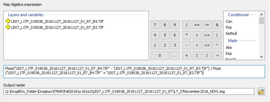
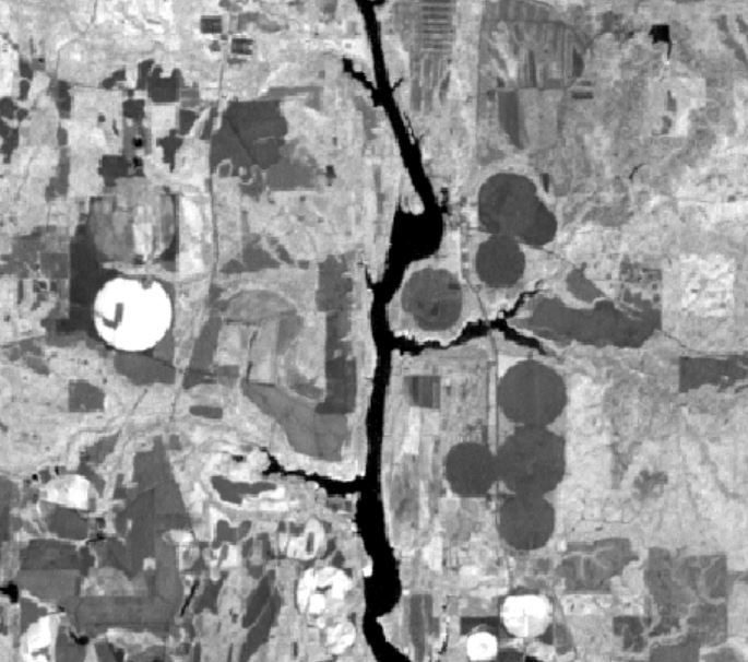
The Float operator ensures the expression is executed using real numbers instead of integers. This is important since NDVI is a real number between -1 and 1. Areas with green vegetation (forests, rotation crops) have a high NDVI and areas void of green chlorophyll (water bodies, bare dirt) have a low NDVI. Zoom into an area with multiple irrigated fields, the round features in this image are irrigated cropland, and you will see what I am talking about!