There are two components to lab 6. First you will dump your 10 Garmin GPSMAP64 GPS data points and will view them in ArcMap. After this, you will use both the Garmin and the Trimble units to map the greenspace in front of Warnell. Your deliverable for this lab is a (zipped) file geodatabase populated with your GPS data.
GPS Information…
Garmin GPSMAP64
The Garmin GPSMAP64 is considered a recreational-grade GPS receiver. These units are relatively inexpensive and very easy to use. In ideal situations, these units may even yield accurate data, however, much of our work is carried out under canopy and other sub-optimal conditions. You should expect an accuracy (ahem, error) of 10 to 15 meters or more when using these devices in the woods.
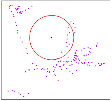
Consider the image below (from Bettinger 2013). The purple dots are the result of a Garmin Oregon 450t data collection in a hardwood forest. The black dot in the middle of the red circle (3 meter radius) represents the true location and the purple dots are the actual XY location given by the GPS. Only 10 of the 150 readings were within the 3-meter radius. This should give you pause when considering using one of these units for important data collection!
Trimble Juno GPS & SoloForest
The Trimble Juno GPS units are considered forester-grade receivers. Under ideal circumstances, you should expect an accuracy of around 3 meters. The SoloForest software allows for the collection of averaged points, lines and polygons. I will post links to documentation here and on ELC as the need arises.
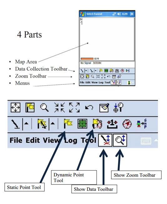
SOLO FOREST INTERFACE:
When mapping a site, you should collect data as a series of points and lines. Collect an average point (at least 30 hits) anywhere the feature’s boundary or shape changes direction or at any location of interest (trail intersections, stream crossings, etc). While walking to the next point, record a line.
Dump your 10 Garmin GPSMAP64 points:
For this part, you will 1) use DNRGPS to dump your 10 data points you collected with the GARMIN64 GPS as a text file, 2) import the text file into a file geodatabase, 3) create an event theme, then 4) save the event theme out as a feature class in the file geodatabase you created.
- Dump your Garmin GPSMAP64 data to your c:\lab6 workspace (DNRGPS Instructions)
– Use NAD83 >> UTM zone 17N as the user-defined projection
– Export it as a ‘Text File, comma-delimited (.TXT)’ - Load your data into a file geodatabase.
– create a new, empty file geodatabase in your working directory, call it mygpsdata
– import the text file into the FGDB (from ArcMap, right-click on the FGDB > Import > Table) - Create an Event Theme (Display as XY Data)
– Load the text file (from 2) into your ArcMap project
– Right-click on the table you just loaded > Display as XY Data
—– if you use the Lat/Long coordinates, your coordinate system will be geographic >> world >> wgs 1984
—– if you use y_proj and x_proj coordinates,, your coordinate system will be projected >> UTM >> NAD 1983 >> NAD 1983 UTM Zone 17N
– export the event theme as a FGDB feature layer
—– right-click on the event theme >> data >> export data >> (make sure you change the save as type to ‘File and Personal Geodatabase feature class), and name the new FGDB feature “MyTenPoints_<LastName>“
GPS data collection of green space outside of Warnell
Today, spend 45 minutes mapping the sidewalk, grassy area, trees, light poles and benches inside the green box. Don’t worry about shrubs. Plan to be back in the lab at 1:15.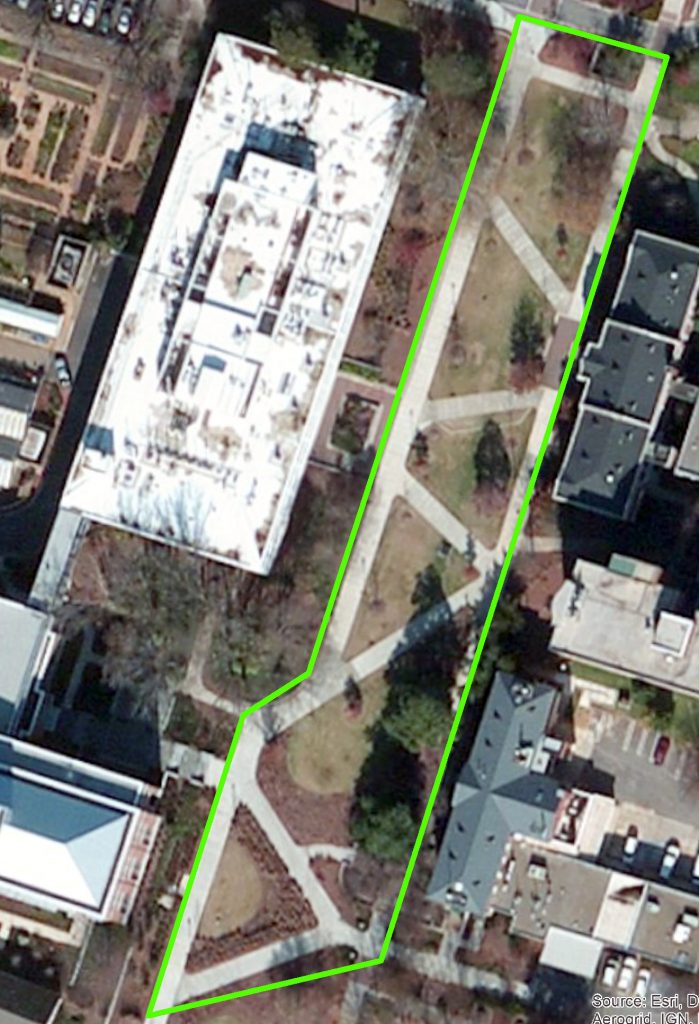
- Mark points anywhere a feature’s shape changes direction, at the base of any tree or light pole, or at any bench. When mapping the sidewalk, mark points on its inside and outside boundary. (HINT: it only takes two points to define a line; it only takes three points to define a triangle!)
- I will step you through the process of uploading the GPS data you just collected to your computer.
- After dumping your Juno GPS data, import it into the file geodatabase you created earlier (right-click on the file geodatabase in the Catalog > Import > Feature Class (Single). You will have to do this twice, once for the line shapefile and again for the point shapefile.
I will look at these files to make sure you successfully delivered a file geodatabase with three feature classes – one point feature class from the Garmin (10 points), one line feature class from the Juno (10 points), one point feature class from the Juno (10 points)
Compress (zip) your FGDB and upload it to the lab 6 dropbox (close ArcMap first) – no map required for this lab. Open File Explorer and navigate to your c:\Lab6 directory then right-click on the mygps.fgd folder > Send To > Compressed (zipped) folder