Pay attention to 1) how the layer's shapes change and 2) what information is contained in the output's attribute table.
We have received notice of the planned 2018 operations on the Walton county property (map below). The consulting forester sent us shapefiles containing the 2015 cover type, the locations of the proposed 2018 operations, the adjacent river, and the soil type.
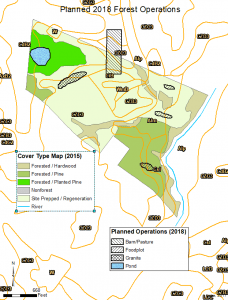
We need to:
- Update the cover type map
- Tabulate the area of each current cover type that transitions to something new in 2018
- A new easement will be established around all areas within 200’ of a pond or river, and 100’ around the granite outcrop. Tabulate areas once this easement is established.
- For mapping purposes, we need to show only the soils within the property boundary.