This lab is pulled from the ESRI 2003 Spatial Labs material. Mr. Glen Jordan is the creator of this exercise.
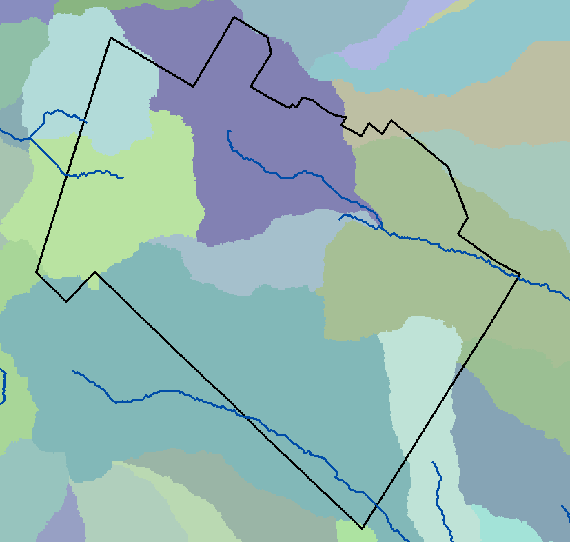
Download this lab’s data here. Set up your lab workspace, extract and load all the layers to a new instance of ArcMap. This site is located in the Acadian-New England forest region of North America.
Download this lab’s Watershed Delineation Toolset. Copy over to your workspace and unzip. This is an ArcMap Toolbox that contains a model to help you delineate a watershed.
- CoverType_Dissolve: covertype layer containing type, crown closure, material size, mean age, mean total volume (MEAN_TV), and mean harvestable volume (MEAN_VH)
- DEM_IDW: is a raster layer where each cell contains an elevation measurement for that cell’s location
Download this lab’s instruction document. Copy it over to your workspace and unzip. This lab is from the ESRI 2013 Spatial Labs training material and was created by Mr. Glen Jordan.
NOTICE: You will use ArcScene in this lab to view layers in 3D. Access ArcScene through the Start menu…
NOTICE: Anywhere you see ‘DEM_Woodlot’, substitute ‘DEM_IDW’
NOTICE: There is nothing to turn in next Thursday for this lab. You will, however, have an in-class-exercise Monday to see if you at least read the lab and one Wednesday that will be specific to a layer you create while working through this lab. So, when you are finished working on this lab, zip your working directory and copy it up to your network workspace.
- Copy all files over to your workspace folder (mine is c:\oa\)
- Unzip the FGDB into your workspace folder (be careful to unzip the files directly into your workspace folder; ensure there are no strange characters in the FGDB’s path)
- Create a folder called “Output” in your workspace folder (c:\oa\Output)
- Load the Spatial Analyst extension (Customize>Extensions>SpatialAnalyst)
- Set Current and Scratch Workspace (Geoprocessing>Environment Settings>Workspace>…)
- Point to your Acadian_Woodlot.gdb
- Create a folder in your
- Run Watershed Delineation tool, turn all layers off, then view each output:
- flowacc (ArcGIS Help): Properties>Symbology>Classified>Classify…>Standard Deviation (1 Std Dev)
- light cells have more (other) cells flowing into it; these are most likely the rivers and streams
- flowdirection (ArcGIS Help): cell values reflect the direction water will flow; 1=East, 4=South, 16=west, 64=north
- watershed (ArcGIS Help): Properties>Symbology>Unique Values
- unique cell values represent individual watersheds based on the streams derived from the flowacc
- flowacc (ArcGIS Help): Properties>Symbology>Classified>Classify…>Standard Deviation (1 Std Dev)
- Turn on the ‘stream’ layer and the ‘Boundary’ layer. Symbolize so you can see all three layers. Zoom to the Boundary layer extent.
- Figure out the Pixel Value of each watershed that touches the western stream (2 of them), the northern stream (3 of them), the southern stream (1 of them). Use the Information button.
- Western stream values:
- Northern stream values:
- Southern stream vakyes:
- Use the Raster Calculator to reclassify the western watershed. Copy/Paster the following calculation into the RC and name the output ‘ws_west’
Con(("watershed" == 86) | ("watershed" == 98),1,0) - Use the Raster Calculator to reclassify the northern watershed. Copy/Paster the following calculation into the RC and name the output ‘ws_north’
Con(("watershed" == 99) | ("watershed" == 103) | ("watershed" == 105),2,0) - Use the Raster Calculator to reclassify the southern watershed. Copy/Paster the following calculation into the RC and name the output ‘ws_south’
Con(("watershed" == 119) | ("watershed" == 130) ,3,0) - Use the RC to merge the ws_west, ws_north, and ws_south layers to create a new raster called ‘ws_all’
"ws_west" + "ws_north" + "ws_south"
- Query ‘CoverTypes_Dissolve’ layer for clearcuts and create a selection layer
TYPE <> 'BG' AND MEAN_AGE >= 0 AND MEAN_AGE <= 5
How would you calculate the exact amount of clearcutting in each of the Woodlot watersheds?
For each watershed, you’re looking for the tally of its cells that fall within a clearcut. Stated another way, you want to labelreclassifyeach of the cells within each clearcut with its associated watershed.
A map algebra Over overlay will easily accomplish the latter, but you’ll first have to build a raster of the 27 clearcuts.
- Convert selected Cover Types features to a 10 m cell-size raster using the Feature to Raster tool (Conversion Tools » To Raster). Name it simply Clearcuts.
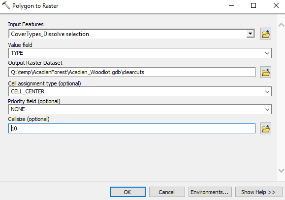
Why are you using a 10 m cell size for Clearcuts? It’s the same cell size as that of the Watersheds raster. Since you’ll be overlaying the two, having the same cell size makes sense.
- Use the Raster Calculator tool (Spatial Analyst » Map Algebra) to enter the following map algebra expression. Name the output raster CCWatersheds.
Over("ws_all","clearcuts")

Cell by cell, an Over overlay simply replaces values in the second raster (bottom) with those of the first raster (top) wherever nonzero values exist. In this case, it has the effect of labeling clearcuts with their associated watershed.
How many acres of clearcuts do we have in the western, northern, and southern watershed?
- Open the cc_watersheds attribute table
- Add a FLOAT field called RASTERAC
- Use the Field Calculator to apply the following:
(10 * 10 * 3.28 * 3.28 / 43560 ) * [Count]
WEDNESDAY… (Grab the data packet for today HERE)
Download the MPK linked above and copy it over to your C:\oa\ workspace. Use 7Zip to extract the data into your workspace (right-click on the MPK>7Zip>Extract Here) – creates a ‘Lab10Redo’ folder in your working directory. Enter the Lab10Redo/v105 folder and open the Lab10Redo ArcMap project.
Open the ws_all attribute table and compute the total acreage of clearcuts in each watershed.
- Add ‘myacre’ FLOAT field, use field calculator to convert 10m2 cell to acres and multiply by COUNT
What percentages of watershed area, however, do these amounts represent? How might you determine that, since watershed areas are stored in the Watersheds raster?
Compute the acreage of each watershed, add new FLOAT field called CCPCT join the ws_all attribute table to cc_watersheds based on VALUE, use field calculator again to calculate percentage.
Up to this point, we have used the raster data model to address our management question “what percentage of each watershed is in clearcut?”. To figure out road mileage in each watershed, you will:
- Use the MERGE command to combine the Main_Road_Centerlines, Secondary_Roads, and Public_Roads layers
- Create a selection layer that excludes the sewer line and powerline easements
CLASS <> 'PE' AND CLASS <> 'SE'
After submitting this query against the merged roads layer, right-click>Selection>Create Layer From Selected Featurs
- Convert the watersheds to a polygon using the Raster To Polygon tool (no simplification)
- Intersect your watershed polygons and your merged roads (don’t forget to recalculate geometry)
and to figure out road/stream crossings you will
- Intersect your roads (from the last step) and streams (from the Permanent_Streams layer)
Can you figure out how to
- Determine road kilometer/watershed?
- Determine the number of stream crossings/watershed?