Lab 01 follow-up…
I’ve stored my Lab 01 document HERE. Those of you with your laptop and ArcGIS installed, download the file then double-click to open my ArcMap project. For your reference, an ArcGIS map package (MPK) is essentially a complete GIS project – it is an ArcMap-readable compressed file that contains the map document, data, and any other document loaded when the file is created. Create an ArcMap Map Package by FILE > SHARE AS > MAP PACKAGE.
Whitehall Seedling Spacing Study Site
This site was harvested in the fall of 2015, herbicided in the summer of 2016 and replanted in the fall of 2016. Six research plots were established to study the effects of seedling spacing on survival rate. Plot size is approximately 0.3 acres and seedling density ranges from 300 trees per acre to 1200 trees per acre. The image above shows the transition from 1200 tpa to 900 tpa.
Application of automated seedling recognition
- Enhanced inventory where we use a combination field inventory (costly and time-consuming) with automated seedling counts – $$$
- Quickly map seedling survival throughout the new stand; assess the stand after flooding or other disaster; assist in the decision to remediate or start over
- Novel approaches to assess stand health and growth – maybe percent tree crown instead of or in addition to trees per acre and height
- …
What I saw during lab Monday
- Always save to your E:\ drive workspace
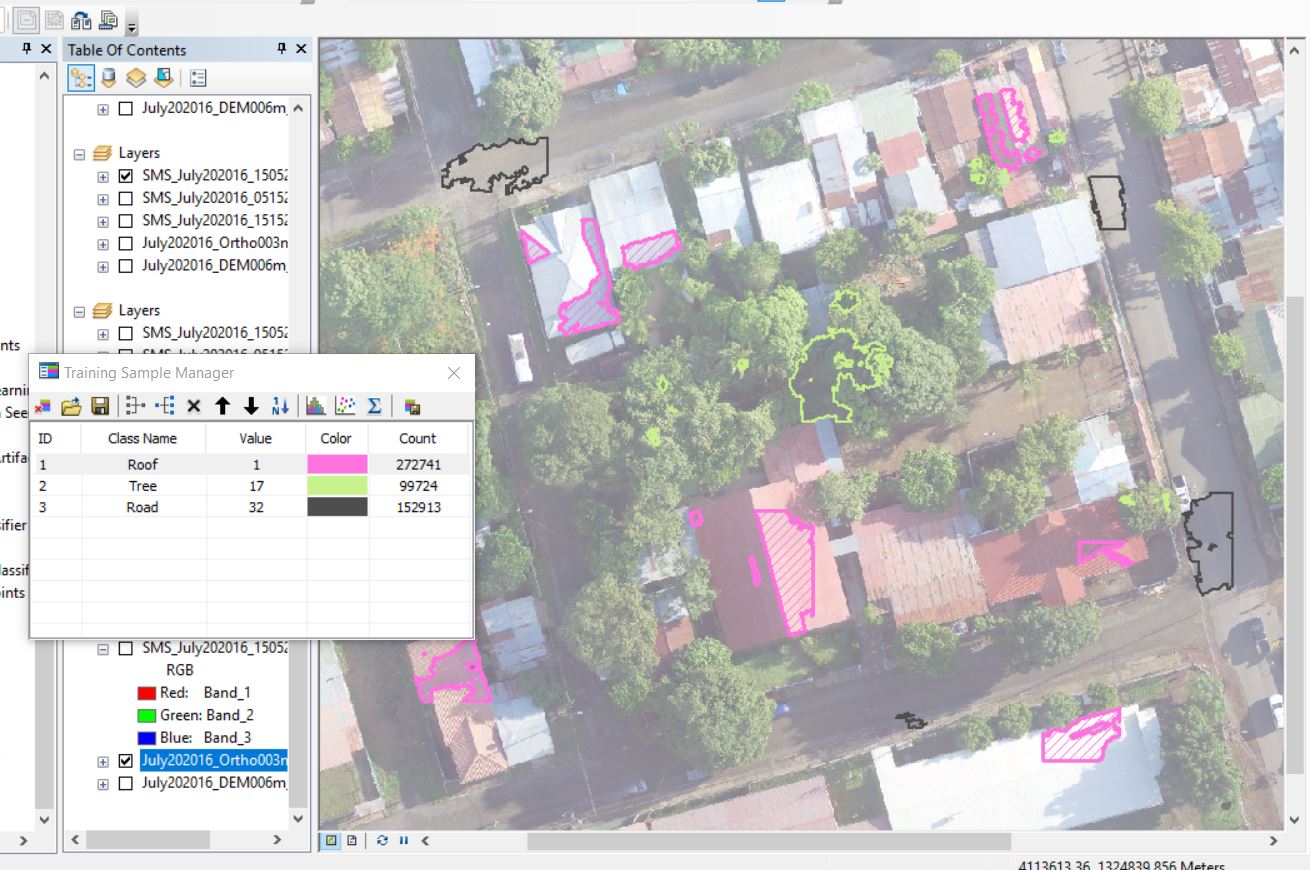
- Collecting signatures
- Compact and homogenous signature (segments at least 30 pixels in size) are better than large/meandering signatures
- You must ensure no category, PINE/SHADOW/BACKGROUND in our example, is magnitudes larger than the other
- Zooming in close allows you to accurately select small segments that you can not access if zoomed out
- The following error message when running the CLASSIFY RASTER command
- the dreaded 999999 error is a general error that indicates something went wrong – not very helpful, I know
- could indicate you did not specify an output image with a .img extension (see the SVM classifyer section below for further details)
- could also mean that you need to save your project and restart ArcMap (this is what ultimately helped me out last night)
- it also might mean that you need to shorten your input/output file names
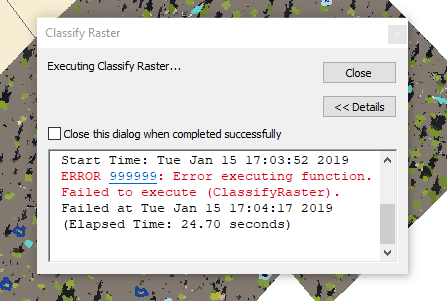
- Your classification can easily turn into an iterative process where you run through the process and your output fails miserably; you return to the signature collection stage, modify the signatures and repeat, repeat, repeat…
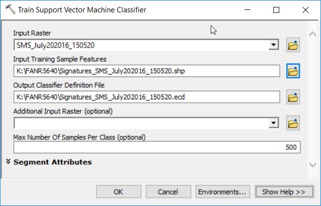
- It is extremely important to use a smart naming convention that allows you to quickly associate inputs and outputs.
- My naming convention
- SMS_150520…
- SMS Segment Mean Shift
- 15 Spectral Detail
- 05 Spatial Detail
- 20 Minimum Segment Size
- SMS_150520…
- You also must be mindful of the length of your filename – try to keep it short as possible while being as descriptive as possible
Same approach, different site
Segmentation: generate homogenous objects – image pixels to image objects
Segment Mean Shift 15/15/20:
Segment Mean Shift 05/15/20: 
Segment Mean Shift 15/05/20: 
Signature creation: This is where you define the objects in which you are interested (trees, roof, road, etc). Use the Image Classification toolbar.
Train your classifier: Generates the statistical description of each class of interest. Simplified example might be ‘roofs are brighter’, ‘trees are green’, and ‘roads are grey’… From ArcMap, we have access to the following classifiers:
- Unsupervised (ISO)
- Supervised Maximum Likelihood
- Supervised Random Trees
- Supervised Support Vector Machine
Each classifier has their pro’s and con’s and some perform better than others in certain circumstances. If you are unsure which may be the best for your work, in addition to searching the literature for key words like “supervised classification” and “image segmentation”, I would start with processing a small subset with each to see how they perform. Furthermore, other software packages like R and QGIS do expose additional classifiers.
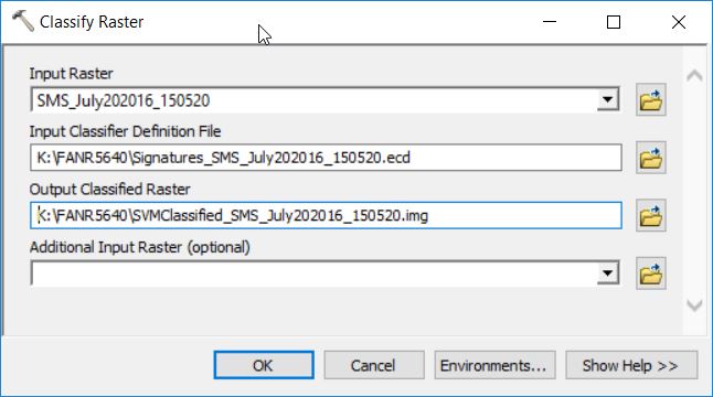
Apply your SVM classifier (CLASSIFY RASTER): You are classifying your segmented raster – performing the Object-Based Image Classification
OUTPUT RASTER: The output raster specified below is WRONG!!! I am trying to save a .img (this extension specifies an ERDAS IMAGE TYPE) inside my file geodatabase. Look at the output raster path “K:\FANR5640\cr.gdb\…”. You are NOT allowed to save ANY file with an extension (.shp, .img, .jpg, etc) inside your file geodatabase. Furthermore, I know that my output path is pointing to my FGDB because I see the “.gdb” in the path name.

My output raster should point to

The full dialog is:
Output:


