Still looking at sectionals…
We will be working through this document this morning.
Airport Terms:
Uncontrolled airport: airport with no control tower
CTAF: “Common Traffic Advisory Frequency”; the VHF frequency used for air-to-air communications
AWOS: “Automated Weather Observing System”; an airport weather system that provides continuous, real time information and reports on airport weather conditions.
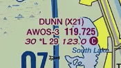
- Airport name – DUNN
- AWOS frequency – 119.725
- Altitude of the airport – 30 feet
- “*L” – means the airport is lighted and the * indicates that the lighting operations are limited
- Length of the longest runway in 100s of feet – 2900 feet
- CTAF – 123.0
Terrain Markings:
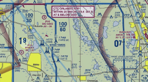
Each quadrant is marked with the maximum elevation plus 100 feet.