Data:
- October 13, 2020 Sentinel-2 image (eLC Link)
- December 18, 2019 Sentinel-2 image (eLC Link)
- Toolbox (extract the Toolbox.tbx and copy it to your working directory) (eLC Link)
Sentinel-2 Satellite Imagery:
- Instructions for download from USGS Earth Explorer (eLC Link)
- Data delivered as single-band rasters
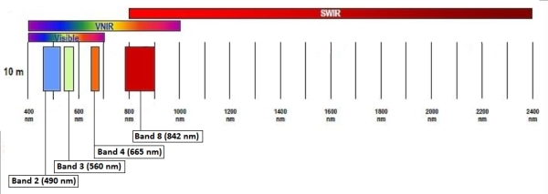
- Sentinel-2 band information
- 10 meter bands (blue, green, red, near-infrared)

Source: https://sentinel.esa.int/web/sentinel/user-guides/sentinel-2-msi/resolutions/spatial
GENERATE A COMPOSITE IMAGE
- Load bands 2, 3, 4, and 8 from the October 13, 2020 Sentinel-2
- These are the single-raster bands containing the responses from the blue, green, red, and near-infrared portions of the spectrum
- Generate a composite image using the COMPOSITE BANDS tool
- Stack bands in this order: 2, 3, 4, 8
- Save the output as S2_202013_b02030408.img
- Don’t forget the “.img” extension
- Explore this layer and try to find: water, forests, fields, urban, …
UNSUPERVISED CLASSIFICATION:
- Perform an unsupervised classification of the October 13, 2020 image using the ISO CLUSTER UNSUPERVISED CLASSIFICATION tool
- Number of classes: 8
- Output classified raster: S2_202013_b02030408_iso8.img
- Minimum class size: 20 (this means that the smallest grouping of contiguous cells is (20*10*10*3.28*3.28/43560) ~ 0.5 acres
- Output signature file: S2_202013_b02030408_iso8_sig.gsg
- Your classified image is a single-layer raster with values ranging from 1 to 8
- Your task is to figure out what land cover type each class represents
- Some classes like VALUE = 1 will be pure (water)
- Some classes like VALUE = 6 will be a mixture of cover types (river and road)
- VALUE = 2:
- VALUE = 3:
- VALUE = 4:
- VALUE = 5:
- VALUE = 7:
- VALUE = 8:
- Repeat the process using the December 18, 2019 image
What differences do you see in the classifications of the October 2020 and the December 2019 image?