Somebody asked about UTM measurements south of the equator… UTM has a north and south zone, each are measurements from the equator…
ESRI: What are map projections?
The above links you to ESRI’s excellent explanation of map projections, coordinate systems, spatial references, and related ArcGIS tasks. You need to review this page and the concept linked in the tables near the bottom of the page.
Overview of Geographic (GCS) and Projected Coordinate Systems (PCS)
The coordinate system is a referencing framework that is used to uniquely define locations on the Earth’s surface. Coordinate systems are defined by the following:
- Its measurement framework, either geographic (coordinates are measured from the Earth’s center) or projected (coordinates are projected onto a two-dimensional planar surface)
- Units of measurement (degrees-minutes-seconds or decimal degrees for geographic CS; meters or feet for projected CS)
- The definition/description of the map projection that is used
- Other measurements such as a spheroid of reference, a datum, one or more standard parallels, a central meridian, and possibly X or Y shifts
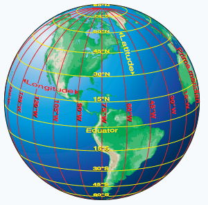
A geographic coordinate system (GCS) references a point by its longitude and latitude values and elevation. Longitude and latitude are angles measured from the earth’s center to a point on the earth’s surface. The angles often are measured in degrees.
While a geographic coordinate system provides a way to accurately determine exact locations, they do not provide uniform units of measure for length and distance. The ground distance between lines of latitude (the Y-axis lines) are constant regardless of one’s location. The ground distance between lines of longitude (the X-axis lines), however, vary depending on where you are. The ground distance between 1-degree of longitude at the Equator is approximately 69 miles and gradually shrinks to 0 at the poles. For example, at 40-degrees latitude, the ground distance between the same two lines of longitude is approximately 53 miles. This is a reason why we don’t use a geographic coordinate system if we need to make area or distance measurements.
A projected coordinate system (PCS), also called a ‘map projection’, defines a referencing system on a flat, two-dimensional surface. Unlike GCS, PCS have constant lengths, angles, and areas across the two dimensional map. Locations are identified by X,Y coordinates on a grid.
Latitude/Longitude:
- Lat/Long is the most common GCS you will use while working in a GIS.
- Latitude defines the Y-coordinate; lines of latitude are parallel; the Equator has a 0 latitude
- Longitude defines the X-coordinate; lines of longitude are NOT parallel; the line of 0 longitude, the prime meridian, passes through Greenwich, England.
- All longitude coordinates are between -180 and 180
- All latitude coordinates are between 90 and -90
- In the USA, all decimal degree longitude values are negative
- In the USA, all decimal degree latitude values are positive

- If the lat/long data were captured with a GPS, it most likely references the WGS84 datum
Universal transverse mercator (UTM)
- Considered a projected coordinate system
- Splits the Earth into 60, 6-degree zones
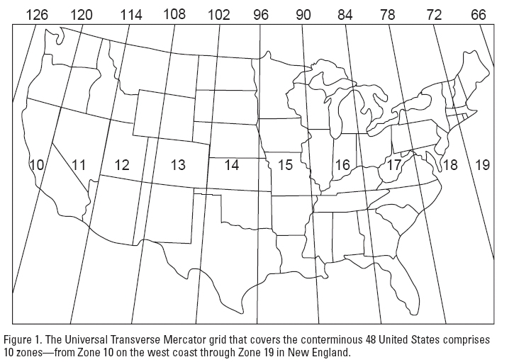
- eastern GA is in UTM zone 17
- western GA is in UTM zone 16
- The UTM unit of measure is meters
- UTM X-coordinate is called the ‘easting’ value
- UTM Y-coordinate is called the ‘northing’ value
- Each zone has an imaginary line running north/south that splits each zone in half called the ‘central meridian’.
- the easting values are arbitrarily 500,000m along the central meridian
- as one moves eastward, the easting value increases (meters)
- as one moves westward, the easting value decreases (meters)
- The northing values measure the distance from the Earth’s equator (meters)
- UTM is designed so, if using the correct zone, all coordinates are positive
- NAIP imagery from NRCS uses UTM and the NAD 1983 datum
State Plane
- Considered a projected coordinate system
- The State Plane coordinate system splits most states either vertically into east/west zones (Georgia, Alabama, Mississippi) or horizontally into north/south zones (Texas, Louisiana). Some states are split vertically and horizontally (Florida has an east, west, and north zone). Finally, some states only have one zone (Tennessee, South Carolina, North Carolina).
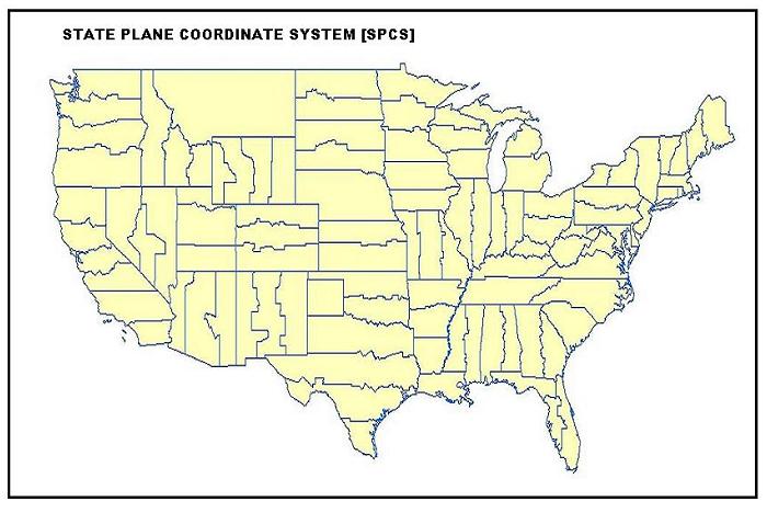
- Traditionally, State Plane uses feet as its unit of measure, however, I have seen folks use meters
Map Projections:
Things you need to know about coordinate systems and ArcMap…
All geographic data you collect with a GPS, you create by digitizing from an already-georeferenced image, or you generate as the result of a GIS analysis have an inherent coordinate system.
- GPS: You set the GPS coordinate system (or it has already been set for you), thus the data you produce uses that same CS
- Digitizing from NAIP imagery: The NAIP aerials have already been georeferenced and exported using a pre-defined coordinate system. When you digitize features from these images, the points/lines/polygons you create inherit the same CS
- GIS analysis: When one performs a GIS analysis, the user first should ensure the input data are cast in the same coordinate system – the output will inherit the same CS
Any time you see an option to define the coordinate system, you should.
- Recall the event theme you created in lab during week 2. The XY coordinate pairs were in Lat/Long, so in the Event Theme dialog, you specified Geographic/World/WGS1984
If you mis-define a layer’s coordinate system, then the layers will not align!
Define projection vs. project vs. data view coordinate system
- Define projection: the user tells ArcGIS the current coordinate system of the data
- Project: an ArcGIS tool that mathematically converts a data layer from one CS to another
- Data view coordinate system: specifies the data view’s coordinate system – all data with a properly defined CS will be projected-on-the-fly to this CS