Geog. Info. Sys. Basics (ch 2.2)
Scale… (Map Scale, Analysis Scale)
Map scale (verbal scale, graphic scale, representative fraction)
Map scales are an expression of the numerical relationship between measurements made on the map (the map units) and the same measurements made on the ground (the ground units).
- Verbal Scale: A textual statement of the map’s scale; the map and ground units do not necessarily have to match: “1 inch = 1 mile” or “1 in. to 660 ft.“
- Graphic Scale: A to-scale bar or ruler drawn on the map; again, the map and ground units do not necessarily have to match; usually in 1/2″ increments
- Representative Fraction (RF): A ratio that expresses the mathematical relationship between the map and ground; map and ground units are the same: “1:24,000” or “1:7920“

Conversion of verbal scale to RF:
- 1 inch to 1200 feet → you must either convert 1 inch to feet or 1200 feet to inches
- after the conversion, the units on both sides of the “to” must be the same
- since this fraction is unitless, this RF scale can be interpreted as “1 inch (on the map) represents 14400 inches (on the ground)“, or “1 chain (on the map) to 14400 chains (chains on the ground)” or “1 thing to 14400 things“
Conversion of RF to verbal scale:
Before you convert RF to a verbal scale, you must decide on the map and ground units – by convention, the map unit is set to 1 inch. Consider the RF scale 1:240000 and I want my verbal scale to reflect “1 inch to XXX feet“. Since we assume the map unit part of this RF is 1 inch, we must assume the ground unit is in inches as well. Thus, your task is to convert 240000 INCHES to feet.
"1 inch to 20,000 feet"
Large Scale vs Small Scale
- Larger scale and Smaller scale are relative descriptions
- 1:100 has a larger scale than 1:2000 (think of these as fractions, 1/100 is a larger number than 1/2000)
- A large scale map covers less area than a small scale map
- A large scale map has more detail than a small scale map
Common RF scales in ArcMap:
- 1:1200 → “1 inch to 100 feet”
- 1:7920 → “1 inch to 660 feet” or “1 inch to 10 chains” (NOTE: 10ch x 10ch = 1 acre)
- 1:12000 → “1 inch to 1000 feet”
- 1:15840 → “1 inch to 1320 feet” or “1 inch to 20 chains” or “1 inch to a quarter mile” (NOTE: 20ch x 20xh = 2 acres)
Setting scale in ArcMap:
You can adjust the scale in both the Data View mode (View >> Data View) and the Layout View mode (View >> Layout View) by typing the appropriate RF in the scale box:

Caution: if you set the scale while in the Data View mode and then switch to the Layout View mode, you must reset the scale!
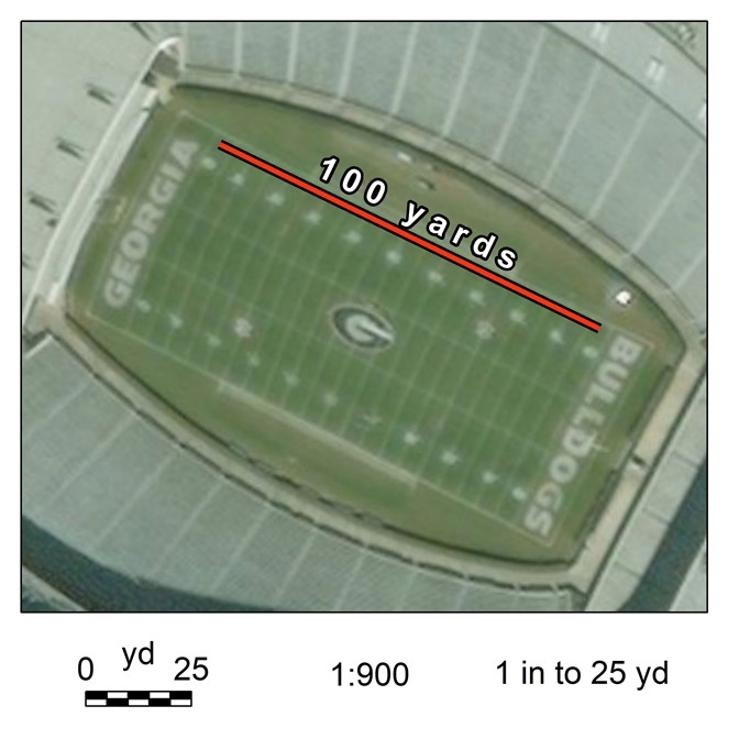
I exported the image below at a scale of 1:900 to a 7″x7″ page size. One inch measured on this paper map represents 25 yards on the ground AND 1 inch on this paper map represents 900 inches.
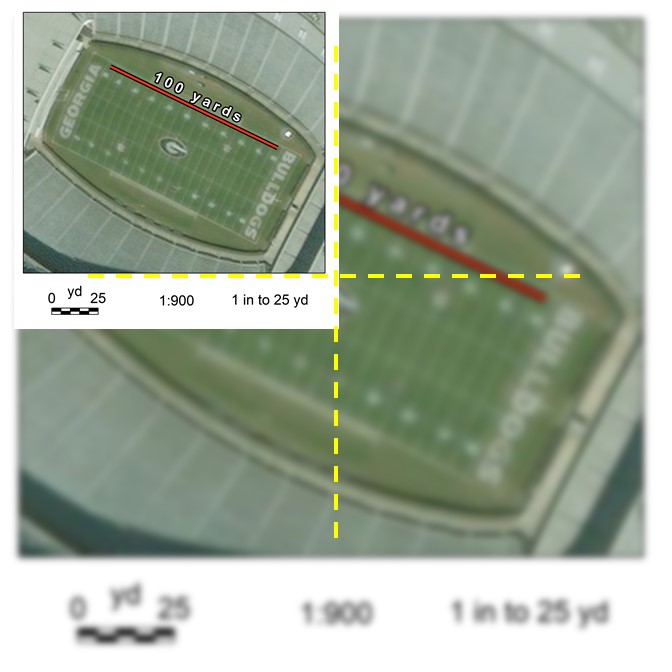
Now, consider the (same) map below. I used PowerPoint to shrink the JPEG to approximately 1/4 the size of the original. If I print this new map out on my 7″x7″ sheet of paper, which scale(s) are still valid? Which scale(s) are wrong?
Analysis Scale
Modifiable Area Unit Problem (MAUP)
MAUP is a problem arising from the imposition of artificial units of spatial reporting on continuous geographical phenomena resulting in the generation of artificial spatial patterns” (Heywood, 1988). In other words, artifacts or errors are created when one groups data into units for analysis.
- The scale at which one chooses to analyze information can produce different results
- The grouping schemes, or zones, that one uses for data analysis can produce different results
- gerrymandering – the act of manipulating an electoral district’s shape for political gain
- ecological fallacy – occurs when one mistakenly assigns a statistic or value that has been calculated for a group to a member of that group
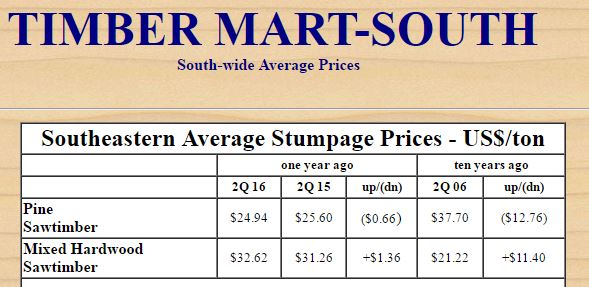
- Does this mean that Mr. Jones will get $24.94/ton for his pine saw timber?