Drone Deploy – Understanding NDVI
ENDVI: https://www.maxmax.com/endvi.htm
Lawn care example: https://www.maxmax.com/lawn_care_2.htm
Harris Geospatial VI list
Normalized Difference Vegetation Index (NDVI)
This index is a measure of healthy, green vegetation. The combination of its normalized difference formulation and use of the highest absorption and reflectance regions of chlorophyll make it robust over a wide range of conditions. It can, however, saturate in dense vegetation conditions when LAI becomes high.
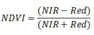
The value of this index ranges from -1 to 1. The common range for green vegetation is 0.2 to 0.8.
Reference: Rouse, J., R. Haas, J. Schell, and D. Deering. Monitoring Vegetation Systems in the Great Plains with ERTS. Third ERTS Symposium, NASA (1973): 309-317.
Visible Atmospherically Resistant Index (VARI)
This index is based on the ARVI and is used to estimate the fraction of vegetation in a scene with low sensitivity to atmospheric effects.
Reference: Gitelson, A., et al. “Vegetation and Soil Lines in Visible Spectral Space: A Concept and Technique for Remote Estimation of Vegetation Fraction. International Journal of Remote Sensing 23 (2002): 2537−2562.
Transformed Difference Vegetation Index (TDVI)
This index is useful for monitoring vegetation cover in urban environments. It does not saturate like NDVI and SAVI.
Reference: Bannari, A., H. Asalhi, and P. Teillet. “Transformed Difference Vegetation Index (TDVI) for Vegetation Cover Mapping” In Proceedings of the Geoscience and Remote Sensing Symposium, IGARSS ’02, IEEE International, Volume 5 (2002).
Simple Ratio (SR)
This index is a ratio of (1) the wavelength with highest reflectance for vegetation and (2) the wavelength of the deepest chlorophyll absorption. The simple equation is easy to understand and is effective over a wide range of conditions. As with the NDVI, it can saturate in dense vegetation when LAI becomes very high.
Reference: Birth, G., and G. McVey. “Measuring the Color of Growing Turf with a Reflectance Spectrophotometer.” Agronomy Journal 60 (1968): 640-643.
Soil Adjusted Vegetation Index (SAVI)
This index is similar to NDVI, but it suppresses the effects of soil pixels. It uses a canopy background adjustment factor, L, which is a function of vegetation density and often requires prior knowledge of vegetation amounts. Huete (1988) suggests an optimal value of L=0.5 to account for first-order soil background variations. This index is best used in areas with relatively sparse vegetation where soil is visible through the canopy.
Reference: Huete, A. “A Soil-Adjusted Vegetation Index (SAVI).” Remote Sensing of Environment 25 (1988): 295-309.
Renormalized Difference Vegetation Index (RDVI)
This index uses the difference between near-infrared and red wavelengths, along with the NDVI, to highlight healthy vegetation. It is insensitive to the effects of soil and sun viewing geometry.
Reference: Roujean, J., and F. Breon. “Estimating PAR Absorbed by Vegetation from Bidirectional Reflectance Measurements.” Remote Sensing of Environment 51 (1995): 375-384.
Optimized Soil Adjusted Vegetation Index (OSAVI)
This index is based on the Soil Adjusted Vegetation Index (SAVI). It uses a standard value of 0.16 for the canopy background adjustment factor. Rondeaux (1996) determined that this value provides greater soil variation than SAVI for low vegetation cover, while demonstrating increased sensitivity to vegetation cover greater than 50%. This index is best used in areas with relatively sparse vegetation where soil is visible through the canopy.
Reference: Rondeaux, G., M. Steven, and F. Baret. “Optimization of Soil-Adjusted Vegetation Indices.” Remote Sensing of Environment 55 (1996): 95-107.
Non-Linear Index (NLI)
This index assumes that the relationship between many vegetation indices and surface biophysical parameters is non-linear. It linearizes relationships with surface parameters that tend to be non-linear.
Reference: Goel, N., and W. Qin. “Influences of Canopy Architecture on Relationships Between Various Vegetation Indices and LAI and Fpar: A Computer Simulation.” Remote Sensing Reviews 10 (1994): 309-347.
Modified Simple Ratio (MSR)
This index was developed an an improvement over RDVI by combining the Simple Ratio into the formula. The result is increased sensitivity to vegetation biophysical parameters.
Reference: Chen, J. “Evaluation of Vegetation Indices and Modified Simple Ratio for Boreal Applications.” Canadian Journal of Remote Sensing 22 (1996): 229-242.
Modified Non-Linear Index (MNLI)
This index is an enhancement to the Non-Linear Index (NLI) that incorporates the Soil Adjusted Vegetation Index (SAVI) to account for the soil background. ENVI uses a canopy background adjustment factor (L) value of 0.5.
Reference: Yang, Z., P. Willis, and R. Mueller. “Impact of Band-Ratio Enhanced AWIFS Image to Crop Classification Accuracy.” Proceedings of the Pecora 17 Remote Sensing Symposium (2008), Denver, CO.
Enhanced Vegetation Index (EVI)
This index was developed as a standard MODIS product to improve the NDVI by optimizing the vegetation signal in LAI regions. It uses the blue reflectance region to correct for soil background signals and to reduce atmospheric influences, including aerosol scattering. It is most useful in LAI regions where the NDVI may saturate.
Leaf Area Index (LAI)
This index is used to estimate foliage cover and to forecast crop growth and yield.
Where EVI is the Enhanced Vegetation Index value.
Reference: Boegh, E., H. Soegaard, N. Broge, C. Hasager, N. Jensen, K. Schelde, and A. Thomsen. “Airborne Multi-spectral Data for Quantifying Leaf Area Index, Nitrogen Concentration and Photosynthetic Efficiency in Agriculture.” Remote Sensing of Environment 81, no. 2-3 (2002): 179-193.
Green Normalized Difference Vegetation Index (GNDVI)
This index is similar to NDVI except that it measures the green spectrum from 540 to 570 nm instead of the red spectrum. This index is more sensitive to chlorophyll concentration than NDVI.
Reference: Gitelson, A., and M. Merzlyak. “Remote Sensing of Chlorophyll Concentration in Higher Plant Leaves.” Advances in Space Research 22 (1998): 689-692.
Green Ratio Vegetation Index (GRVI)
This index is sensitive to photosynthetic rates in forest canopies, as green and red reflectances are strongly influenced by changes in leaf pigments.
Reference: Sripada, R., et al. “Aerial Color Infrared Photography for Determining Early In-season Nitrogen Requirements in Corn.” Agronomy Journal 98 (2006): 968-977.
Infrared Percentage Vegetation Index (IPVI)
This index is functionally the same as NDVI, but it is computationally faster. Values range from 0 to 1.
Reference: Crippen, R. “Calculating the Vegetation Index Faster.” Remote Sensing of Environment 34 (1990): 71-73.