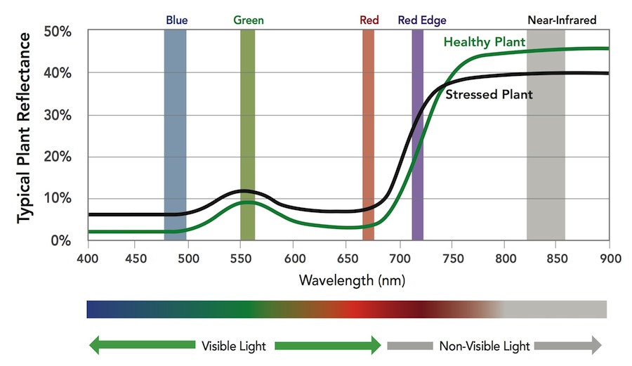
Drone Deploy – Understanding NDVI ENDVI: https://www.maxmax.com/endvi.htm Lawn care example: https://www.maxmax.com/lawn_care_2.htm Harris Geospatial VI list Normalized Difference Vegetation Index (NDVI) This index is a measure of healthy, green vegetation. The combination of its normalized difference formulation and use of the highest absorption and reflectance regions of chlorophyll make it robust over […]
Spring2017
9 posts

OpenDroneMap (opendronemap.org) ODM on github Installation: The easiest way to get ODM up and running is to install through a Docker image (Instructions). Video showing how to spin up an Amazon AWS & ODM (here) My ODM install: Ubuntu 16.04 Server Cinnamon desktop environment Run ODM through docker Example ODM […]
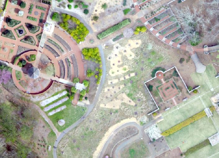
UGA Botanical Garden UAV We’re going to change gears a bit and look at a data set I collected at the UGA Botanical garden on March 19, 2016. UGA Botanical Garden UAV Data SAGA GIS 4.0.1 Download (SAGA GIS Create bare ground model from LIDAR) Following the workflow described here […]
Global Positioning System (GPS) About: The 24 satellites that make up the GPS space segment are orbiting the earth 11,000 to 12,000 miles above us. They are constantly moving, making two complete orbits in less than 24 hours. These satellites are travelling at speeds of roughly 7,000 miles an […]
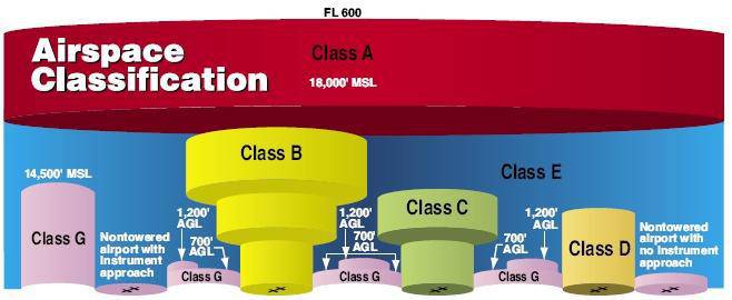
Part 107 Topics: Sectional Charts & Airspace (source: https://3dr.com/faa/study-guides/airspace/) Sectional Charts: Digital downloads: https://www.faa.gov/air_traffic/flight_info/aeronav/digital_products/vfr/ are meant to only show a section of a flight region emphasize landmarks and features that would be used by manned aircraft for navigation include tall man-made structures, natural landmarks, roads, rivers, power lines, and […]
Sample Data Here Overlay Analysis We have already reviewed one overlay (selection) analysis tool – Select By Location. Recall, with this method, you select whole records in one layer that are spatially related in some manner (intersects, within a distance…, center is within…, etc) to another layer (Select By Location). This method works […]
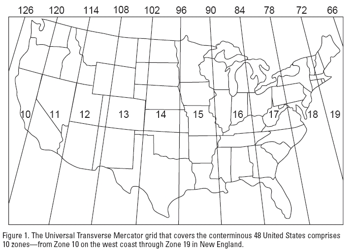
(http://www.gsd.harvard.edu/gis/manual/projections/) Things you should know about coordinate systems and ArcGIS: In ArcMap, the coordinate system consists of a projection, a datum, and a unit of measure. To make things easy for the user, ArcMap has many of them already defined in the software. Latitude/Longitude is considered an unprojected coordinate system […]
Follow-up of Monday’s Lab Photoscan Workflow: Add Photos (Align Photos*) Insert/Locate ground control points Align Photos (again) Build Dense Cloud Build Mesh Build DEM Build Orthomosaic Export DEM and Ortho Problem with GPS Altitude EXIF tag lab data set: Current Phantom 4 firmware populates the GPS Altitude tag with the […]
Instructor: Dr. Roger ‘Tripp’ Lowe (lowe@uga.edu) Lectures: Wed & Fri (9:05 – 9:55) in 1-210 Labs: Mon (1:25 – 3:20) in room 4-419 Course Objectives: I plan to introduce you to the unique aspects of integrating small unmanned aircraft systems (sUAS) into the sustainable natural resource management workflow. We will explore […]