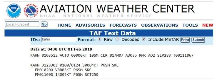
TAFs: Terminal Aerodrome Forecast
We are talking about TAFs this morning in class. Recall that a METAR is a weather report of the current conditions. A TAF, on the other hand, is a weather forecast of expected conditions.
Today’s lecture may seem repetitious after talking about METARs Wednesday… Today’s lecture may seem repetitious after talking about METARs Wednesday… Both weather strings use the same cryptic codes. There are some differences between the two – you should know them by the end of class.
Document for today: https://business.desu.edu/sites/business/files/document/16/metar_and_taf_codes.pdf (page 19; this is a very useful document for studying METARs and TAFs)
Notes:
- aviationweather.gov
- TAF expands and forecasts what is expected to happen with the weather
- Extends up to 6 statute miles
- CB = cumulonimbus = thunder showers
- Ceiling is the lowest broken (BKN) or overcast (OVC) layer (few (FEW) and scattered (SCT) is not considered when determining the cloud ceiling)
- cloud heights are reported in hundreds of feet above ground level (AGL)
- P stands for greater than; M stands for less than
- VCSH: vicinity, SH: showers, RA: Rain, FM: from, TS: thunder storms
- TAFs are good for a time frame (that is indicated in the TAF string)
- TAFs are distinguished from a METAR by its multiple date/time groupings
Good informational link:
The Complete Guide to Understanding METARS – Part I
The Complete Guide to Understanding METARS – Part II
KAHN 010352Z: 