Improvement of clip by extent example from Wednesday… The following code clips the LAS to the boundary of the shapefile. (example data)
library(lidR)
library(rgdal)

setwd("c:/temp/sf/")
tdat<- readLAS("sp2_pcloud.las")
plot(tdat)

tpoly<- readOGR( ".","AnalysisUnit")

clpdat <- lasclipPolygon(tdat,
 tpoly@polygons[[1]]@Polygons[[1]]@coords[,1],
 tpoly@polygons[[1]]@Polygons[[1]]@coords[,2])

plot(clpdat)
COARSE WOODY DEBRIS EXAMPLE:
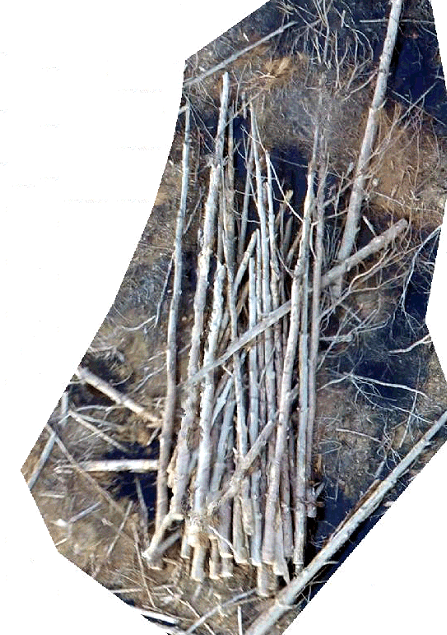
Task at hand is to determine the volume (m3) of the oriented pile shown in the following image.

SUPPORTING INFORMATION:
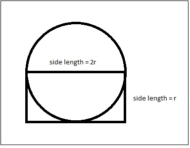
The volume of a cylindrical object is misrepresented in rasterized products derived from nadir imagery (as seen above). The surface of visible objects are represented true-to-form while the parts not visible in the image are squared (figure 1). We will use a correction factor of 0.8798 to correct our estimates.

Figure . Example of how UAV imagery views stems and CWD.
See Brian Davis’ thesis, Refinement of a drone-based method for estimating coarse woody debris and biomass residue following forest harvest, for more background, procedures, and project results (https://athenaeum.libs.uga.edu/handle/10724/37140).
GLOBAL MAPPER WORKFLOW:
- Clip LAS to pile’s boundary
- Classify ground surface
- Isolate stems
- …
Clip LAS in Global Mapper
- MAKE A BACKUP OF YOUR LAS FILE (copy/paste in Windows Explorer)
- Load LAS & polygon shapefile boundary
- Select LAS points
- Use Digitizer tool to select polygon boundary
- Turn on ONLY boundary layer
- Select digitizer tool (icon with pencil)
- Click on polygon
- Turn on the point cloud layer
- Right-click on polygon > Advanced Selection Options > Select all Point Features within the Selected Area(s)
- Use Digitizer tool to select polygon boundary
- Invert selection
- Turn on ONLY LAS layer
- Right-click > Advanced Selection Options > Invert Selection
- Delete selected (points not in polygon)
- Righ-click > Delete – Delete Selected Feature(s)
… Continued…