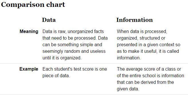
Data are the facts or details from which information is derived
Throughout this course, know that we are combining data on the basis of location and individual attributes to form actionable information…
Anatomy of a mapping project
You receive a request from a client who is planning for upcoming harvests. They need the following:
- Total stand acreage
- Acreage of each land cover type
- The UTM zone 17N X & Y coordinates of the three proposed logging deck sites
- Maps showing the most recent aerial and topo
Where do you start?
- Determine exactly what you need
- Locate the property (street address, Google Earth, GPS, road map, survey, etc)
- Plan/organize working directory
- Locate existing GIS data (local image and GIS layer archive, previous mapping projects)
- Compile other spatial data – imagery from NRCS, QPublic, state GIS clearinghouses
- Prepare project file geodatabase
- Import existing GIS data
- Extract imagery to FGDB
- Create new boundary and new covertype polygon feature classes and logging_deck point feature class (possibly others like interior_road, gate_entrances, stream_crossings, etc)
- Go ahead and add a gisacres (float) and gistype (text) field to boundary and covertype layer
- Add UTMx (float) and UTMy (float) fields to logging_deck layer
- Create data
- Digitize property boundary into the boundary layer
- Digitize cover types
- Copy property boundary feature (select boundary feature then right-click on boundary feature >> copy) and paste it into the covertype layer (right-click >> paste – make sure you paste into the covertype layer)
- Delineate the various cover types into the covertype layer – use the cut tool
- Attribute each polygon you cut as you go
- Digitize logging deck locations
- Populate UTMx and UTMy fields (right-click >> calculate geometry >> …)
- Generate covertype/acreage summaries
- From attribute table, right-click on type field >> Summarize >> fill in the Summarize dialog
- Generate maps