(http://www.gsd.harvard.edu/gis/manual/projections/)
Things you should know about coordinate systems and ArcGIS:
- In ArcMap, the coordinate system consists of a projection, a datum, and a unit of measure. To make things easy for the user, ArcMap has many of them already defined in the software.
- Latitude/Longitude is considered an unprojected coordinate system
- UTM and State Plane are considered a projected coordinate system
- If you are dealing with state, multi-state, or continental data, choose one of the projected>continental projections. Otherwise, you will most likely use UTM or State Plane.
- The coordinate system is inherent in your data
- Examples:
- You captured a series of points with your GPS. The receiver was programmed to capture coordinates using a specific coordinate system. Your points in the GIS inherit the coordinate system of the GPS.
- You digitize your forest from a NAIP orthophoto that has been projected into the UTM/Zone17N/NAD83/Meters. Any data you create inherits that coordinate system. Furthermore, when you create your shapefile for digitizing, you must set its coordinate system to match.
- It is up to you to ensure your data’s coordinate system is properly defined.
- Examples:
- However, the coordinate system must be properly and correctly defined before ArcGIS will display it in the ‘right’ location. If a data set’s coordinate system is improperly defined, then your data layers will not overlay. When you zoom to full extent, then everything disappears.
- A layer’s coordinate system and the ArcMap Dataframe coordinate system are two different properties.
- The layer’s coordinate system defines the coordinate information that is inherent to the data (ie. These points were captured with a GPS unit set to collect in Lat/long; these roads were digitized from an aerial photograph that was cast in UTM/NAD83/ZONE17N/METERS, or this aerial photograph was georeferenced to the Georgia State Plane East coordinate system).
- The data frame’s coordinate system defines the coordinate system that will be used to display all layers. ArcMap will project “on the fly” almost all layers with a properly-defined coordinate system to match this data frame coordinate system.
Determining a layer’s coordinate system:
- Read the accompanying metadata
- Ask the creator of the data (“What coordinate system (projection/zone, datum, units of measure, etc) does this data set use?”).
- Figure it out by trial and error. This involves displaying the layer with an unknown coordinate system in one instance of ArcMap and comparing coordinates from the map display with those from another ArcMap project (a second instance of ArcMap running) that displays a data layer with a known coordinate system.
When you are dealing with GIS data at the non-state and non-national level, the three most common coordinate systems you will encounter are Lat/Long, UTM, and State Plane.
- Lat/Long coordinates (in decimal degrees) for Athens are (-83.385, 33.96):
- All longitude coordinates are between -180 and 180
- All latitude coordinates are between 90 and -90
- If the data were captured using a GPS unit, try the WGS 1984 (WGS84) datum. If that fails, then try the NAD 1983 (NAD83) datum
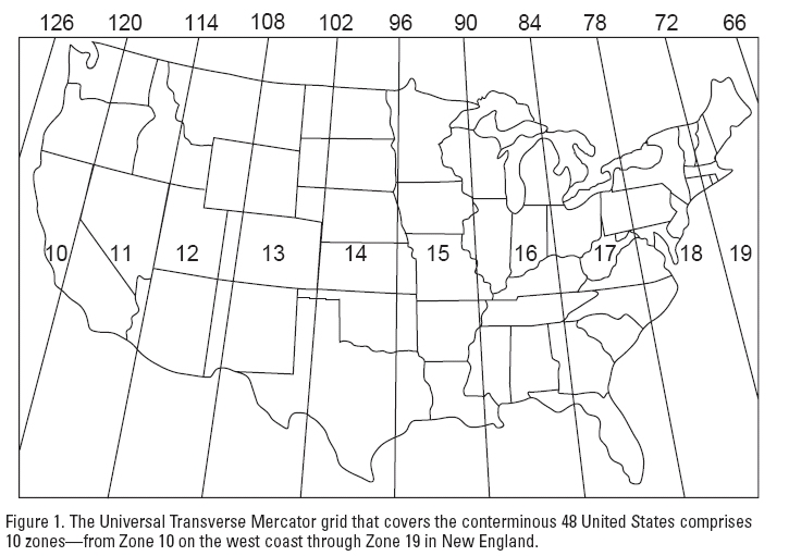
- UTM (zone 17) coordinates for Athens are (276,775 easting value, 3,760,100 northing value)

- UTM easting values (along the horizontal X-axis) range from ~100,000 to ~900,000
- UTM northing values (along the vertical Y-axis, measured in meters from the equator) range from 0 at the equator to ~9,300,000 in the northern hemisphere
- UTM coordinate system is designed so no coordinate value is negative
- The center of each zone is arbitrarily assigned an X coordinate of 500,000
- Count up in meters as you head east of this central meridian
- Count down in meters as you head west of this central meridian
- The center of each zone is arbitrarily assigned an X coordinate of 500,000
- Unless you have a good reason to use something else, use the NAD 1983 (NAD83) datum with UTM
- State Plane coordinates
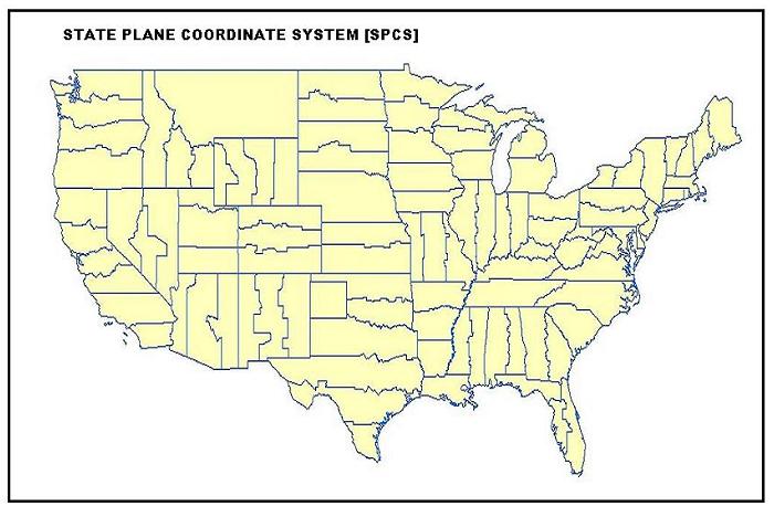
- The State Plane coordinate system splits most states either vertically into east/west zones (Georgia, Alabama, Mississippi) or horizontally into north/south zones (Texas, Louisiana). Some states are split vertically and horizontally (Florida has an east, west, and north zone). Finally, some states only have one zone (Tennessee, South Carolina, North Carolina).
- Traditionally, State Plane uses feet as its unit of measure, however, I have seen folks use meters
- Try the NAD 1983 datum first (especially for new data layers). If this does not work, then try the NAD 1927 (NAD27) datum.

-
- You will most likely know what part of the state your data is in, and you should be able to determine that your data is not using UTM, so you can make an educated guess at which zone. If that does not work, try the other zone.
FOR YOUR REFERENCE:
Lets assume you have a layer that does not align with all of the layers in your project, or you receive a warning that the layer ‘has an undefined spatial reference’ each time you load it. These are the steps you should follow to try identify the correct coordinate system…
- Start ArcGIS but do not load a layer at this point
- Navigate to your layer using the Catalog
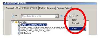
- Right-click on the layer > Properties > XY Coordinate System tab
- Select Clear under the “Add Coordinate System” button – this removes the existing coordinate system definition (since the layers did not align, then its coordinate system is most likely defined incorrectly)
- Now, load the layer into your empty ArcMap project
- You will get an “Unknown Spatial Reference” warning. Hit OK.
- For good measure, clear the ArcMap Data Frame coordinate system
- View pull-down-menu > Data Frame Properties > Coordinate System tab > (clear it just as you did in step ii)
- Mouse over the data layer and look at the coordinates in the bottom right
- Do you see decimal degrees (lat/long)?
- Do the numbers look like UTM coordinates?
- Measure something with a known width. Is it in feet or meters?
- Start a new instance of ArcMap and load a layer whose coordinate system is known and properly defined. Any layer you download from the NRCS or the Georgia GIS Clearinghouse will work fine.
- Change the Data Frame coordinate system (View pull-down menu>Data Frame Properties>Coordinate System tab) to common coordinate systems until the coordinates in the bottom right match those coordinates in the first instance of ArcMap.
- Common projected coordinate systems for Georgia are:
- UTM/Zone 17N (Zone 16N)/NAD83?Meters
- State Plane Georgia East (or West)
- NAD83/Meters
- NAD83/Feet
- NAD27/Feet
- NAD27/Meters
- When you do have a match, go back to the catalog and define the layer’s coordinate system
