
#####Code based on https://erinbecker.github.io/r-raster-vector-geospatial/10-vector-csv-to-shapefile-in-r/index.html #####load libraries library("sf") library("raster") #####Set working path, input text file name, output shapefile name mypath<- "~/r-docker-tutorial/lIlk" myfile<- "20201015_1130wetland8.TXT" outfile<- "emi_20201015_1130wetland8.shp" #####Read CSV into a data frame named mydat mydat<- read.csv(file.path(mypath,myfile), na.strings = "NA") nrow(mydat) #####Remove all rows whose longitude value is NA mydat<- subset(mydat, !is.na(mydat$WGS84_LON)) […]
Monthly Archives: November 2020
5 posts
For the second part of your How-To notebook, you will design, execute, assess, revise and repeat a spatial analysis component of your research project. Specifically, I want you to: Identify one spatial analysis component of your research project; those of you working on a non-thesis degree, find a project […]
This R script allows the user to process multiple LAS/LAZ files at once using the catalog functionality of the lidR library. If you look closely, this and the R code from Monday are almost identical. Line 12, here, we create a LAS catalog instead of reading in an individual LAS […]
Using LAZ point cloud linked on our eLC site #####Processing 1 LAZ file. Will generate slope, aspect, and hillshade images; normalize the point cloud; create #####canopy height model and a custom metric #####Save the #####might need to install libraries #####install.packages(lidR) library(lidR) library(rgdal) library(future) plan(multisession, workers = 4L) #####Setting my working […]
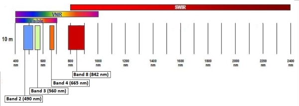
Data: October 13, 2020 Sentinel-2 image (eLC Link) December 18, 2019 Sentinel-2 image (eLC Link) Toolbox (extract the Toolbox.tbx and copy it to your working directory) (eLC Link) Sentinel-2 Satellite Imagery: Instructions for download from USGS Earth Explorer (eLC Link) Data delivered as single-band rasters Sentinel-2 band information 10 meter […]