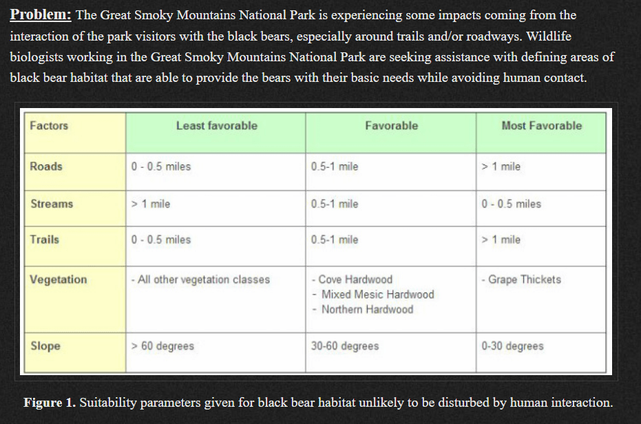
Raster Analysis (Bolstad pages 444 – 474) Consider the following management need. How would you approach this analysis? LOCAL FUNCTIONS: Processes the raster surface cell-by-cell Perform Map Algebra with Raster Calculator and/or the Spatial Analyst tools found in the ArcToolbox You can apply mathematical functions to individual or multiple layers […]
Monthly Archives: October 2018
4 posts
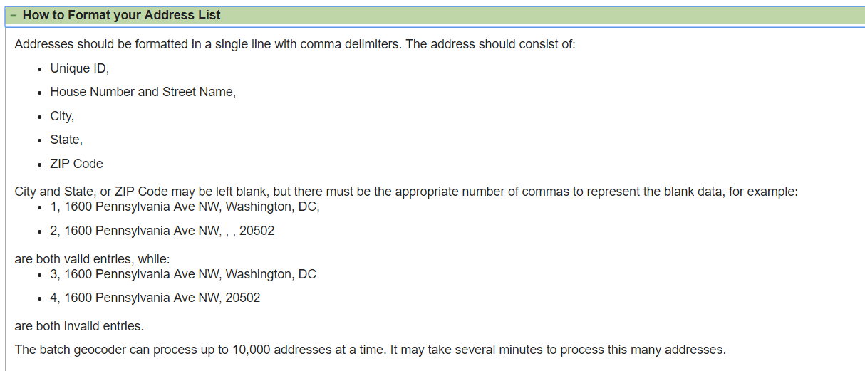
Census’ Batch Geocoder: https://geocoding.geo.census.gov/geocoder/geographies/addressbatch?form Census’ Batch Geocoder documentation: https://www2.census.gov/geo/pdfs/maps-data/data/FAQ_for_Census_Bureau_Public_Geocoder.pdf Association of Consulting Foresters member list: https://www.acf-foresters.org/ACFWeb/Directory/ACFWeb/Find_a_Forester/Directory.aspx Submit a “Last name contains” = % query to return all records. Hit the “Select All” link to show all of the results on one page. Copy the results and paste them into NOTEPAD […]

This week’s lab deliverable: Upload video topics 20, 21, 22, 23, 24, 25 and 26 to this week’s ELC lab assignment dropbox. I suggest you re-read the ArcGIS Video Tasklist instructions before you proceed (http://142.93.66.153/2018/07/12/fanr3800_videotasklist/). If you adhere to the recording guidelines, you can submit the videos to the FinalExamVideos […]
Sumter County Cruise Data Georgia GIS Clearinghouse Historical Imagery https://apps.itos.uga.edu/gsdi_rasterportal/ State: https://apps.itos.uga.edu/gsdi_rasterportal/resources/WMTSCapabilities_Statewide.xml Regional: https://apps.itos.uga.edu/gsdi_rasterportal/resources/WMTSCapabilities_Regional.xml County: https://apps.itos.uga.edu/gsdi_rasterportal/resources/WMTSCapabilities_County.xml Add a WMTS service to your ArcMap project: Open the Catalog window Scroll down and expand the GIS SERVERS selection Double-click ADD WMTS SERVER Paste the WMTS path into URL and hit GET LAYERS Expand the […]