
Spatial Analyst Toolset Must load the Spatial Analyst extension to use these tools – Customize >> Extensions >> … ESRI Spatial Analyst Toolset Listing You’ve used the following tools in lab: Conditional – Raster If/Then operations Distance – When paired with a reclassification, this is how we buffer using the raster data type Extraction (specifically […]
Yearly Archives: 2018
53 posts
Raster Analysis (Bolstad pages 444 – 474) Consider the following management need. How would you approach this analysis? LOCAL FUNCTIONS: Processes the raster surface cell-by-cell Perform Map Algebra with Raster Calculator and/or the Spatial Analyst tools found in the ArcToolbox You can apply mathematical functions to individual or multiple layers […]
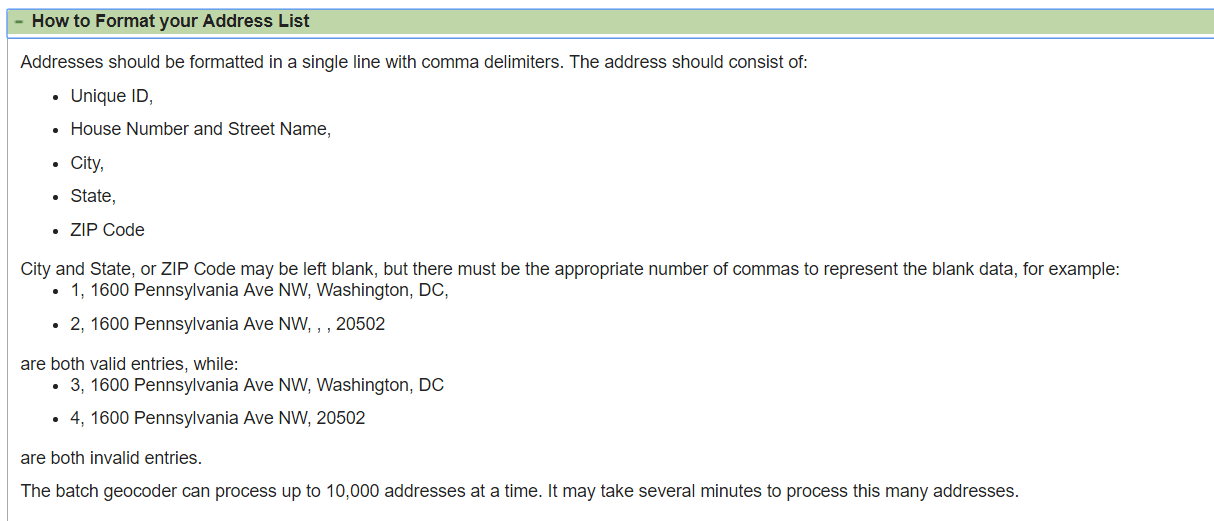
Census’ Batch Geocoder: https://geocoding.geo.census.gov/geocoder/geographies/addressbatch?form Census’ Batch Geocoder documentation: https://www2.census.gov/geo/pdfs/maps-data/data/FAQ_for_Census_Bureau_Public_Geocoder.pdf Association of Consulting Foresters member list: https://www.acf-foresters.org/ACFWeb/Directory/ACFWeb/Find_a_Forester/Directory.aspx Submit a “Last name contains” = % query to return all records. Hit the “Select All” link to show all of the results on one page. Copy the results and paste them into NOTEPAD […]
This week’s lab deliverable: Upload video topics 20, 21, 22, 23, 24, 25 and 26 to this week’s ELC lab assignment dropbox. I suggest you re-read the ArcGIS Video Tasklist instructions before you proceed (http://142.93.66.153/2018/07/12/fanr3800_videotasklist/). If you adhere to the recording guidelines, you can submit the videos to the FinalExamVideos […]
Sumter County Cruise Data Georgia GIS Clearinghouse Historical Imagery https://apps.itos.uga.edu/gsdi_rasterportal/ State: https://apps.itos.uga.edu/gsdi_rasterportal/resources/WMTSCapabilities_Statewide.xml Regional: https://apps.itos.uga.edu/gsdi_rasterportal/resources/WMTSCapabilities_Regional.xml County: https://apps.itos.uga.edu/gsdi_rasterportal/resources/WMTSCapabilities_County.xml Add a WMTS service to your ArcMap project: Open the Catalog window Scroll down and expand the GIS SERVERS selection Double-click ADD WMTS SERVER Paste the WMTS path into URL and hit GET LAYERS Expand the […]
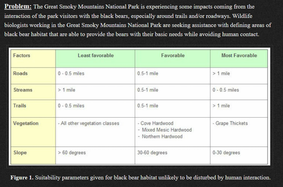
Now that we’ve finished defining our habitat suitability criteria, I want you to implement it in the GIS. We are looking for the areas that are suitable for all four species. I want you to generate a map showing your findings. Submit it to the lab 7 assignment folder by […]
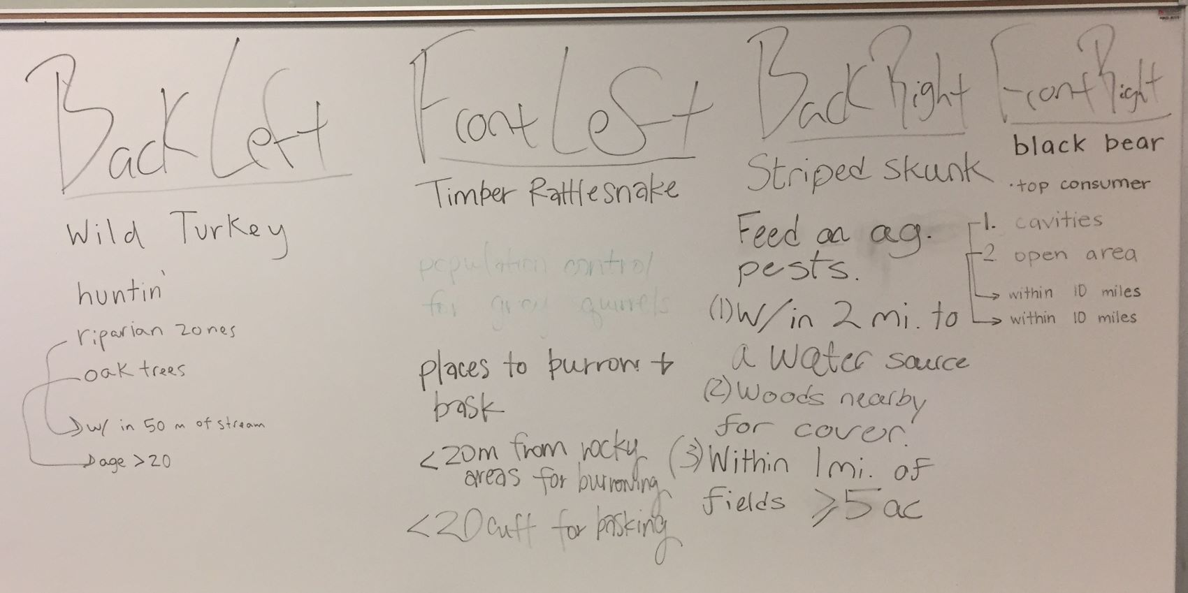
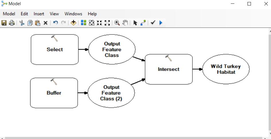
From Monday’s class we’ve determined 1) WHY we would want to manage for our specie of interest, 2) WHAT features on the landscape are important, and 3) HOW these features are defined. Wild Turkey: WHY: hunting revenue WHAT: riparian zones & oak trees (mast producers) HOW: within 50m […]
Georeferencing practice (Oconee Forest Park) OCFP SAMPLE DATA Set up your ArcMap project Load your georeferenced source image (NAIP2015_Source.jpg) Ensure your data frame coordinate system matches the NAIP (UTM17/NAD83/Zone17N…) Load your ungeoreferenced target image this layer is not georeferenced, you will not see it when it loads Save the project to your workspace Locate possible ground […]
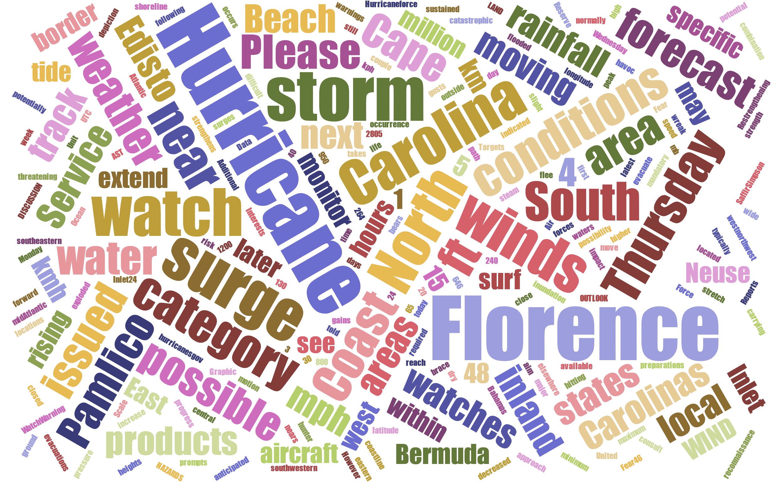
NOAA BULLETIN – SUMMARY OF WATCHES AND WARNINGS IN EFFECT: A Storm Surge Watch is in effect for… * Edisto Beach South Carolina to the North Carolina-Virginia border * Albemarle and Pamlico Sounds, including the Neuse and Pamlico Rivers A Hurricane Watch is in effect for… * Edisto Beach South Carolina […]

Data Download the RCW data linked on our ELC site. Copy the zipped file over to your working folder on the E:\ drive and unzip it. I converted the data to feature classes in a file geodatabase. We realized that there were inconsistencies with the original shapefiles (2/13/2020). The […]