
3. (40 points) A week later, you get an email detailing yet another change. He wants to convert the southern corner to longleaf pine, the northwestern corner to slash, retain three irrigated crop fields, and put the remaining non-hardwood into loblolly. For this scenario, he needs to know […]
2. (24 points) Two days later, you hear back from the client. He has decided to convert some of the area to Irrigated Cropland. The WGS84 LONG/LAT center pivot coordinates and pivot arm radii are listed in Appendix 3. For this scenario, the client needs to know how […]
1. (16 points) Your client is interested in the Battle Creek package listed here and needs more information about the property before purchase. Specifically, how many acres have been previously clearcut and how many acres are in hardwood (anything other than clearcut)? The property boundary GPS coordinates […]
Your FORS 7690 lab exam consists of 5 questions… Record your answers in a WORD document and, upon completion, upload it and any other information I request to the ELC Lab Exam assignment dropbox. I recommend you save your project often. Your answers to the ‘How many acres…’ […]
Open source GIS software (alternatives to ArcGIS) GIS LOUNGE’s list of open source gis (https://www.gislounge.com/open-source-gis-applications/) Quantum GIS (https://qgis.org/en/site/) Use the OSGeo4W installer to install on Windows (https://trac.osgeo.org/osgeo4w/) Others of note: gvSIG MapWindow GIS GIS tasks you should now be very comfortable with completing Creating new vector data: digitizing, […]
UAV-based Seedling Survival Count Measuring Survival and Planting Quality in New Pine Plantations(Andrew J. and Stephen G. 2006) BFGrant Demo Data (300MB) – download, copy the file to your C:\ workspace, right-click on the MXD > 7Zip > Extract Here, open the ../v105/Untitled.mxd ArcGIS project. figure out where the image is […]
Downlowd ArcMap Project (250MB) Download the MPK then copy it over to your C:\ workspace. Right-click on the MPK file > 7Zip > Extract Here. Navigate to the v105 folder and then open the ImgClassification.mxd ArcMap project. The data you are looking at are from a flight on December 14, […]
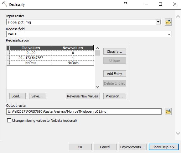
Spatial Analyst Toolset Must load the Spatial Analyst extension to use these tools – Customize >> Extensions >> … ESRI Spatial Analyst Toolset Listing In last week’s lab, you used the following tools: Conditional – Raster If/Then operations Distance – When paired with a reclassification, this is how we buffer using the raster data type […]
(Use UTM Zone 17N for all work) For the site you select, they would like a 50-mile radius report detailing the: acres of evergreen, deciduous, mixed, wetlands (woody and herbaceous), and urban landcover acres of forested land within a ½ mile of a primary or secondary road percentage […]
Four groups Group 1: first 2 rows on the left Group 2: first 2 rows on the right Group 3: remaining rows on the left Group 4: remaining rows on the right The Georgia Forestry Commission has a client who wants to establish a softwood mill somewhere […]