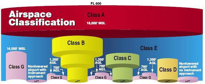
Part 107 Topics: Sectional Charts & Airspace (source: https://3dr.com/faa/study-guides/airspace/) Sectional Charts: Digital downloads: https://www.faa.gov/air_traffic/flight_info/aeronav/digital_products/vfr/ are meant to only show a section of a flight region emphasize landmarks and features that would be used by manned aircraft for navigation include tall man-made structures, natural landmarks, roads, rivers, power lines, and […]
Daily Archives: February 20, 2017
2 posts

Sample Data Here Overlay Analysis We have already reviewed one overlay (selection) analysis tool – Select By Location. Recall, with this method, you select whole records in one layer that are spatially related in some manner (intersects, within a distance…, center is within…, etc) to another layer (Select By Location). This method works […]