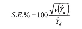
The Enhanced Forest Inventory and Analysis Program – National Sampling Design and Estimation Procedures (http://www.treesearch.fs.fed.us/pubs/20371) FIA standards: PDF page 24 (starting w/ last paragraph) Plot Layout: PDF page 39 Derivation of population estimates: PDF page 53 Sampling Error: PDF page 69 Used by FIA to reflect the accuracy of the […]
Monthly Archives: September 2016
10 posts
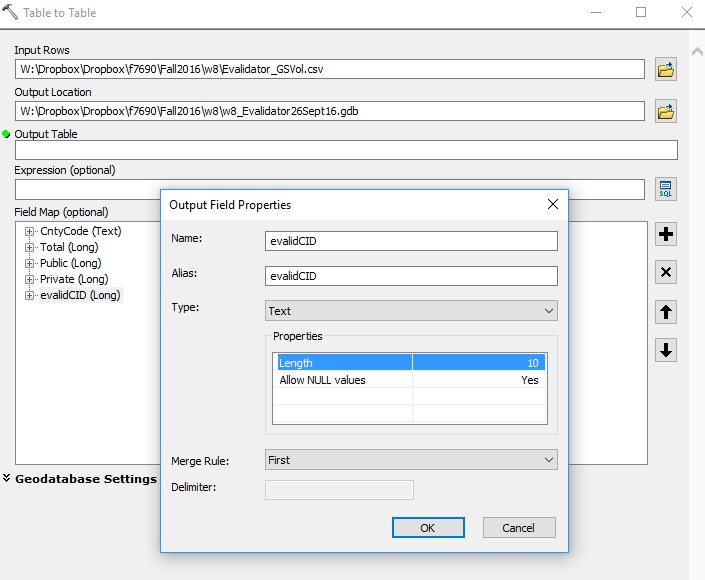
In today's demonstration, I will walk you through the process of joining an Evalidator query result to a data layer in ArcMap. We will use the Evalidator reports and the 2015 Census county boundaries in this zip file (here) . While the context of my example today may or may not […]
In today's lab, need to first answer two simple questions: 1) which Georiga 115th Congressional district has the most private timberland acreage and 2) how does the median real estate tax paid in this district compare to the other districts adjacent to it? In addition, answer the following: - The […]

American FactFinder: (https://factfinder.census.gov/) NOTE: The subsections for each bulleted step below tell you how to perform the task. Visit AFF >> Advanced Search >> SHOW ME ALL Filter to Congressional District Click Geographies on left-hand side of screen Select “Congressional District” from the dialog dropdown Select “All Congressional Districts (115th Congress…)” […]
Forest Products Network (http://www.forestproductslocator.org/welcome) … The Primary Forest Products Locator website is provided by the Southern Group of State Foresters to assist buyers with locating primary wood product manufacturing companies. These companies produce “renewable” products by converting recently harvested trees from managed forests to lumber, wood panels, paper, and many […]
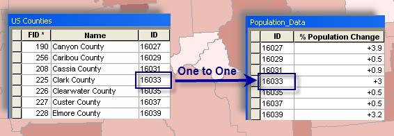
Join external tabular data to existing spatial data When joining an external table to a spatial layer in ArcGIS, you must… have a common field in the external table with values that match values in a field in the spatial layer have either a one-to-one relationship or a many-to-one relationship […]
Data Types: Tabular Data Common types used in GIS xls, xlsx, txt, csv, dbf First 4 types can be viewed in Excel using File>Open To view a dBase file (.dbf), you must open an Excel worksheet and then drag the file from Windows Explorer and drop it into the blank […]
Georeferencing scanned maps The data you have been working with so far has been prepared for somewhat easy incorporation into ArcMap. Data scientists from the NRCS Geospatial Data Gateway carefully processed the aerials you used in last week’s lab; ensuring all of the roads, rivers, buildings, etc. were in their proper […]

Your task for this lab is to create marketing material for a timberland parcel being advertised on the Land Watch website. You will 1) locate teh parcel in QPublic, 2) download multiple years worth of aerial photos, soils, hydrology, watershed boundaries, and roads from the NRCS Geospatial Data Gateway, 3) […]
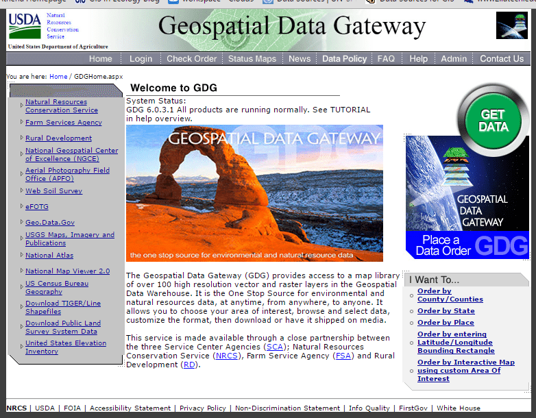
NRCS Geospatial Data Gateway (https://gdg.sc.egov.usda.gov/GDGHome.aspx) "The Geospatial Data Gateway (GDG) provides access to a map library of over 100 high resolution vector and raster layers in the Geospatial Data Warehouse. It is the One Stop Source for environmental and natural resources data, at anytime, from anywhere, to anyone. It allows […]