‘Are you getting the accuracy you expect with Pix4Dmapper?’ 1 1 https://pix4d.com/getting-expected-accuracy-pix4dmapper/, last accessed 2/27/2018. Project Summary: Original flight with a Phantom 4 Pro with 95% frontlap and 90% endlap and a 2.9cm ground sampling distance (GSD). The GSD is the distance between two consecutive pixel centers measured on the ground. For […]
Monthly Archives: February 2018
9 posts

An Unmanned Aerial System (UAS) includes the 1) aircraft or airframe, 2) its payload, and 3) the ground control system/station. Table 1 contains a short overview of the aircraft we recently purchased for use here at Warnell. They range from a small DJI Spark that is suitable for practicing flying […]
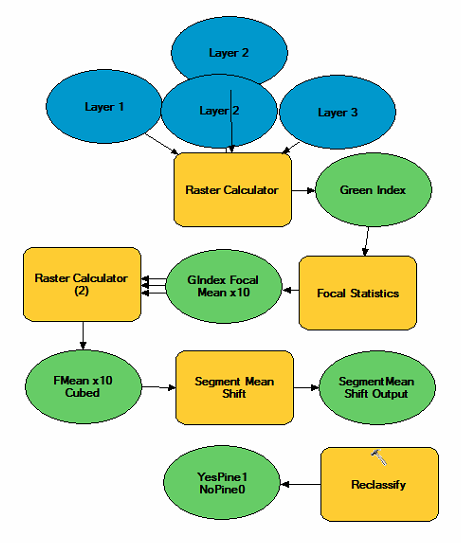
To close out our pine seedling analysis, lets step through a better classification. We will start with this spatial model. As a result, I get this: Use a command called REGION GROUP to combine grouped pixels with the same value and then a series of queries based on the region […]

Common vegetation indices Green Index: Float (Green Layer) / Float (Red + Green + blue) Normalized Difference Vegetation Index “NDVI”: Float( NIR – Red) / Float( NIR + Red) NDVI requires information from the near-infrared range of the electromagnetic spectrum Requires a special sensor that capture that/those portions of the […]
Download the “Lab6Data” file HERE (you can also find the Lab6Data.zip file in our FANR5640_7640 folder on the N:\ Drive). Use File Explorer (type Explorer in the search window in the lower-left of the screen) to copy the zipped file you just downloaded (look in the Downloads folder) […]
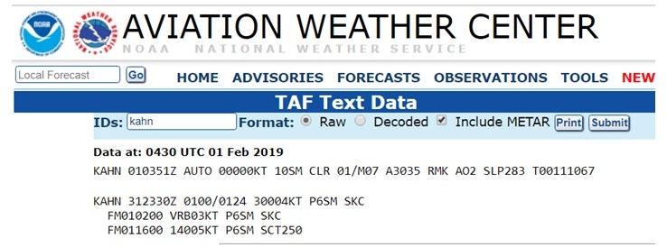
TAFs: Terminal Aerodrome Forecast We are talking about TAFs this morning in class. Recall that a METAR is a weather report of the current conditions. A TAF, on the other hand, is a weather forecast of expected conditions. Today’s lecture may seem repetitious after talking about METARs Wednesday… Today’s lecture […]
METARs: Routine Surface Observations RP101 3.1 METAR Codes aviationweather.gov METAR issued every 55 minutes CB = cumulonimbus = thunder showers Ceiling is the lowest broken or overcast layer (few and scattered is not considered when determining the ceiling) cloud heights are reported in hundreds of feet above ground level (AGL) What are […]
Download Lab Data 1 Download Lab Data 2 The data you are looking at are from a flight on December 14, 2016 in south Georgia. ‘P4_SouthGA_14Dec16_ORTHO02.img’ is the Agisoft 3-band, 0.02 meter resplution, natural-color orthophoto output. ‘P4_SouthGA,14Dec16_DEM08’ is the Agisoft 0.08 meter resolution terrain model generated from the same […]
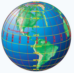
Latitude/Longitude Review Please refer to the graphic below: Latitude refers to the lines that run horizontally, parallel to the Equator. When one moves to the next line of latitude they travel in a north-south direction, they are traveling “up the ladder”. In Cartesian space such as our sectional maps, latitude is a […]