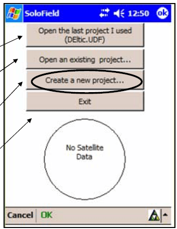
How-To Collect Data with SoloForest and the Flint GPS Units Information in this document is modified from pdf documents put together by Johnny Thompson, LandMark Systems Flint Basics This unit uses a windows operating system and a stylus to navigate Turn the unit on with the on/off button Refresh (turn […]
Monthly Archives: April 2018
8 posts
Photo Info CSV I have over three years of drone photos stored on my computer. Unfortunately, I have not kept track of when/where/why I have flown. I do, however, have only a handful of directories in which I have saved these photos. I need to search specific directories on […]
FORS 5640/7640 Final Exam When: May 2, 2018, from 12 – 3 (if you have a conflict, please let me know as soon as possible) Where: In the GIS Lab Format: Closed book/Closed note; multiple choice Don’t forget upload your Remote Pilot 101 Quiz 1 – 9 […]
Mission planning for vertical surfaces Ground Control Software I will give a short demonstration of four common (DJI-based) ground control software: DJI GO 4, GS Pro, Map Pilot, and Pix4Dcapture. For the most part, flight planning with these software is completed on site, in the field. Agisoft Photoscan I have been […]
There are quite a few ground control software options available for both IOS and Android. Most DJI pilots will use the DJI Go app when first learning how to operate their aircraft manually. Its functionality is limited, however, for those wanting to perform autonomous missions. For these types […]
Lab 10: Coarse woody debris volume remaining after harvest [Excerpt from Brian Davis’ 2017 thesis,”REFINEMENT OF A DRONE-BASED METHOD FOR ESTIMATING COARSE WOODY DEBRIS AND BIOMASS RESIDUE FOLLOWING FOREST HARVEST”] "… Pine forests of the southern US are a major source of woody debris residues used for bioenergy (Milbrandt 2005). […]

We will return to the CWD example Monday Download Sectional Charts in KML format USGS UAS Data Processing in Agisoft Photoscan