Notice to Airmen (NOTAMs): https://pilotweb.nas.faa.gov or https://skyvector.com/ flight planning purposes provides information to airmen which contains pertinent information to increase air safety applies to all pilots drone operators file a NOTAM only if you have a waiver that requires it purposes avoid temporarily restricted areas inform drone pilots […]
FANR5640/7640
50 posts
Lab deliverable is highlighted in Orange about half-way through the lab. Lab 10 is loosely based on the Agisoft Intermediate tutorial posted here: https://www.agisoft.com/index.php?id=35 Download photos from the March, 19, 2016 Botanical Garden flight (HERE). You will need to select all of the photos (tick box in upper […]
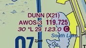
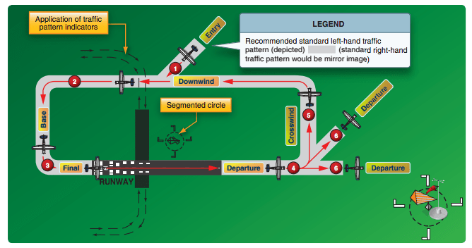
Still looking at sectionals… We will be working through this document this morning. Airport Terms: Uncontrolled airport: airport with no control tower CTAF: “Common Traffic Advisory Frequency”; the VHF frequency used for air-to-air communications AWOS: “Automated Weather Observing System”; an airport weather system that provides continuous, real time information and […]
[Newer version created on 2/2/2021] lidR v3.1.1 & rgdal v 1.5.21 Lab 9 Data Link (clp_tls.laz). This is a large dataset, have patience!!! The “LAZ” file is a common point cloud file format storage type. You read a LAZ the same way you read a LAS – you process […]
Operations near an airport Aguilar – Forza Business Strategies, Inc. Scenario: You present a scenario in which there are two adjacent properties owned by different persons. One has a state-permitted private-use heliport which is used 40 times per month. The other property is a vacant lot where construction has begun […]
Lab08 Data Download Lab 08: Coarse woody debris volume remaining after harvest [Excerpt from Brian Davis’ 2017 thesis,”REFINEMENT OF A DRONE-BASED METHOD FOR ESTIMATING COARSE WOODY DEBRIS AND BIOMASS RESIDUE FOLLOWING FOREST HARVEST”] "… Pine forests of the southern US are a major source of woody debris residues used for […]
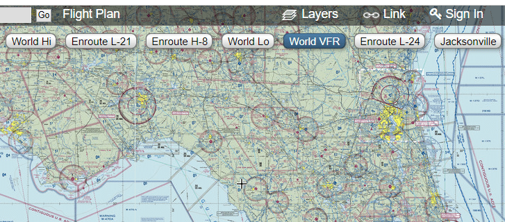
Sectionals: Special Use Areas (prohibited, restricted, warning military operation, alert) SOURCES: http://www.faraim.org/aim/aim-4-03-14-143.html http://www.faraim.org/aim/aim-4-03-14-144.html http://www.faraim.org/aim/aim-4-03-14-145.html http://www.faraim.org/aim/aim-4-03-14-146.html http://www.faraim.org/aim/aim-4-03-14-147.html and https://thinkaviation.net/prohibited-areas/ (www.skyvector.com)… NOTE: Pan/Zoom to your flight area (in this example, the Florida panhandle), then click the link in the upper-right to load the region’s sectional (see screenshots below). Click the “World VFR” […]
B SOLID BLUE C SOLID MAGENTA D DASHED BLUE SURFACE-E DASHED MAGENTA ‘TRANSITION’-E FADED MAGENTA (700′) Sources of airspace information Sectional Charts Download (https://www.faa.gov/air_traffic/flight_info/aeronav/digital_products/vfr/) Airspace (Ch 3 of the Aeronautical Information Manual, AIM) (https://www.faa.gov/air_traffic/publications/atpubs/aim_html/index.html). Pay attention to the airspace class definitions (3-2-3 thru 3-2-6). Excellent sectionals document by the Cessna […]
Pixels To Points Help In this lab, you will be processing drone data acquired on February 07, 2020 at the terraced section of the UGA Botanical Garden. The photos were captured with the DJI Phantom 4 Professional using the DJI Ground Station software running on an iPAD mini; the drone […]
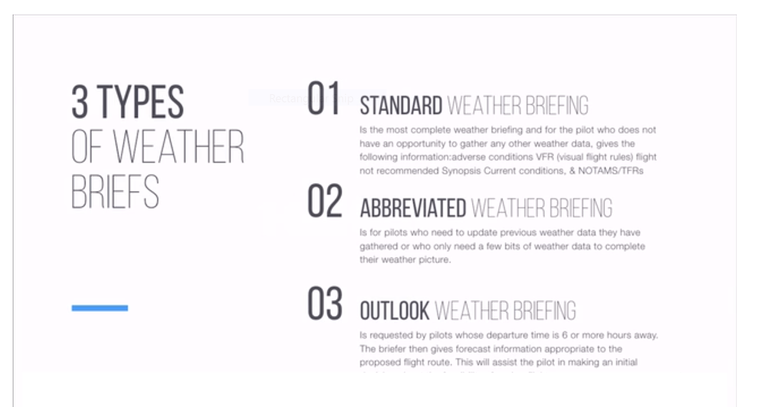
Weather Info, See: FAA Remote Pilot – Small Unmanned Aircraft Systems Study Guide (Chapter 3a & 3b) Drone U Part 107 Drone Certificate Study Guide (Section III, p83…) FAA UAS Test Study Guide by Kelsey Mason (see Weather Theory Stuff section) Weather notes… These are topics that will appear […]