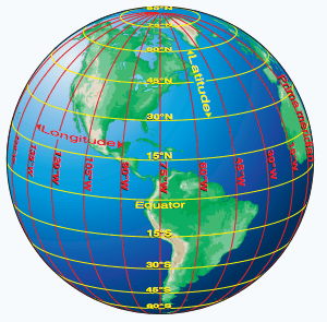
Latitude/Longitude Review Please refer to the graphic below: Latitude refers to the lines that run horizontally, parallel to the Equator. When one moves to the next line of latitude they travel in a north-south direction, they are traveling “up the ladder”. In Cartesian space such as our sectional maps, latitude is a […]
FANR5640/7640
50 posts
Download the following three compressed files and unzip them (preferably to a new folder you create on the C:\ drive). Whitehall Dam Photos (Download Link) My Whitehall Dam ReCap Photo w/out GCP Output (Download Link) My Whitehall Dam ReCap Photo with GCP output (Download Link) Stack Profile Line Shapefile (Download Link) Last […]
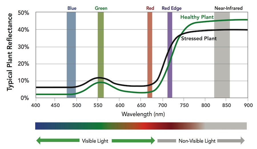
Drone Deploy – Understanding NDVI ENDVI: https://www.maxmax.com/endvi.htm Lawn care example: https://www.maxmax.com/lawn_care_2.htm Harris Geospatial VI list Normalized Difference Vegetation Index (NDVI) This index is a measure of healthy, green vegetation. The combination of its normalized difference formulation and use of the highest absorption and reflectance regions of chlorophyll make it robust over […]

OpenDroneMap (opendronemap.org) ODM on github Installation: The easiest way to get ODM up and running is to install through a Docker image (Instructions). Video showing how to spin up an Amazon AWS & ODM (here) My ODM install: Ubuntu 16.04 Server Cinnamon desktop environment Run ODM through docker Example ODM […]
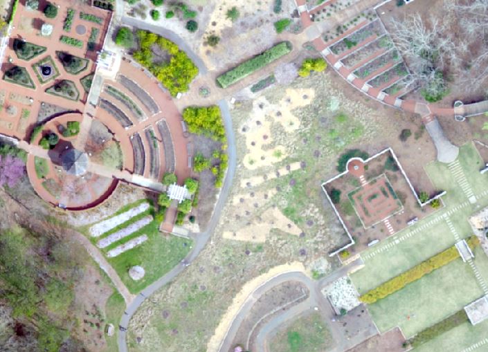
UGA Botanical Garden UAV We’re going to change gears a bit and look at a data set I collected at the UGA Botanical garden on March 19, 2016. UGA Botanical Garden UAV Data SAGA GIS 4.0.1 Download (SAGA GIS Create bare ground model from LIDAR) Following the workflow described here […]
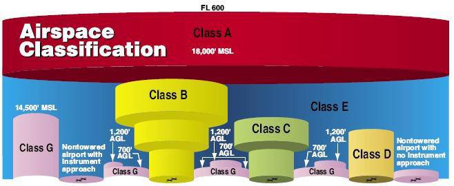
Part 107 Topics: Sectional Charts & Airspace (source: https://3dr.com/faa/study-guides/airspace/) Sectional Charts: Digital downloads: https://www.faa.gov/air_traffic/flight_info/aeronav/digital_products/vfr/ are meant to only show a section of a flight region emphasize landmarks and features that would be used by manned aircraft for navigation include tall man-made structures, natural landmarks, roads, rivers, power lines, and […]
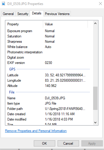
Follow-up of Monday’s Lab Photoscan Workflow: Add Photos (Align Photos*) Insert/Locate ground control points Align Photos (again) Build Dense Cloud Build Mesh Build DEM Build Orthomosaic Export DEM and Ortho Problem with GPS Altitude EXIF tag lab data set: Current Phantom 4 firmware populates the GPS Altitude tag with the […]
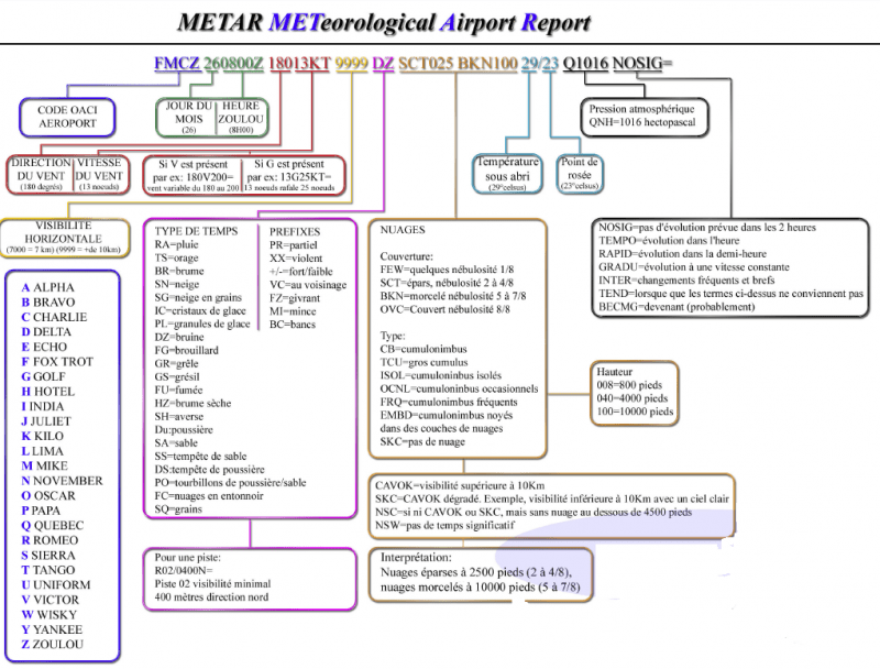
METARs: Routine Surface Observations RP101 3.1 METAR Cheat Sheet aviationweather.gov METAR issued every 55 minutes CB = cumulonimbus = thunder showers Ceiling is the lowest broken or overcast layer (few and scattered is not considered when determining the ceiling) cloud heights are reported in hundreds of feet above ground […]
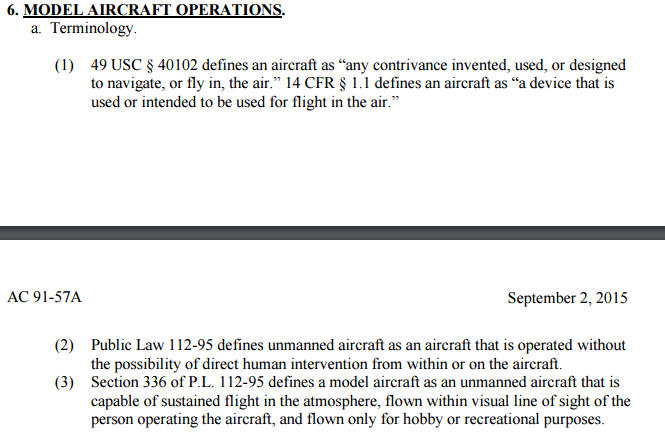
(3) Little bit of background Congress recognized the FAA’s authority to regulate airspace use, management, and efficiency, air traffic control safety, navigational facilities, and aircraft noise at its source (49 U.S.C. §§ 40103, 44502, and 44701-44735. 1978) The FAA Modernization and Reform Act of 2012(1a, 1b), the FMRA, […]
Instructor: Dr. Roger ‘Tripp’ Lowe (lowe@uga.edu) Lectures: Wed & Fri (9:05 – 9:55) in 1-210 Labs: Mon (1:25 – 3:20) in room 4-419 Course Objectives: I plan to introduce you to the unique aspects of integrating small unmanned aircraft systems (sUAS) into the sustainable natural resource management workflow. We will explore […]