Global Positioning System (GPS) About: The 24 satellites that make up the GPS space segment are orbiting the earth 11,000 to 12,000 miles above us. They are constantly moving, making two complete orbits in less than 24 hours. These satellites are travelling at speeds of roughly 7,000 miles an […]
Monthly Archives: February 2017
4 posts
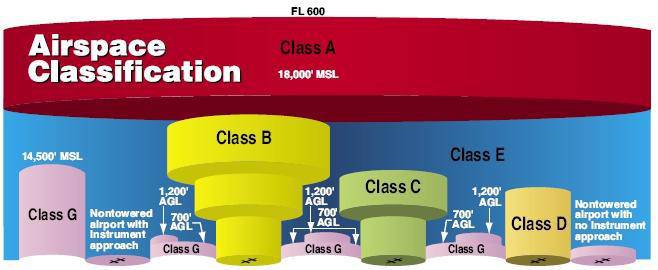
Part 107 Topics: Sectional Charts & Airspace (source: https://3dr.com/faa/study-guides/airspace/) Sectional Charts: Digital downloads: https://www.faa.gov/air_traffic/flight_info/aeronav/digital_products/vfr/ are meant to only show a section of a flight region emphasize landmarks and features that would be used by manned aircraft for navigation include tall man-made structures, natural landmarks, roads, rivers, power lines, and […]

Sample Data Here Overlay Analysis We have already reviewed one overlay (selection) analysis tool – Select By Location. Recall, with this method, you select whole records in one layer that are spatially related in some manner (intersects, within a distance…, center is within…, etc) to another layer (Select By Location). This method works […]
(http://www.gsd.harvard.edu/gis/manual/projections/) Things you should know about coordinate systems and ArcGIS: In ArcMap, the coordinate system consists of a projection, a datum, and a unit of measure. To make things easy for the user, ArcMap has many of them already defined in the software. Latitude/Longitude is considered an unprojected coordinate system […]