
The data I use today can be downloaded HERE Queries and Selections Attribute Query (ArcGIS Attribute Query Help): allows the user to select features in a layer based on the values stored in its attribute table. Select By Location (ArcGIS Select By Location Help): allows the user to select features based on […]
FORS7690
40 posts
In today’s demonstration, I will walk you through the process of joining an Evalidator query result to a data layer in ArcMap. We will use the Evalidator reports and the 2015 Census county boundaries zip file (here). Copy the file to your E:\ drive and uncompress it. You’ll find the county […]
Useful EXCEL VBA Commands: Most of these commands work in EXCEL and ArcGIS Field Calculator. ESRI support has a nice description of these commands in the context of the Field Calculator here and some examples here. left: The Microsoft Excel LEFT function allows you to extract a substring from a string, […]
American FactFinder: (https://factfinder.census.gov/) NOTE: The subsections for each bulleted step below tell you how to perform the task. Visit AFF >> Advanced Search >> SHOW ME ALL Filter to Congressional District Click Geographies on left-hand side of screen Select “Congressional District” from the dialog dropdown Select “All Congressional Districts (115th Congress…)” […]
The Enhanced Forest Inventory and Analysis Program – National Sampling Design and Estimation Procedures (http://www.treesearch.fs.fed.us/pubs/20371) FIA standards: PDF page 24 (starting w/ last paragraph) Plot Layout: PDF page 39 Derivation of population estimates: PDF page 53 Sampling Error: PDF page 69 Used by FIA to reflect the accuracy of the […]
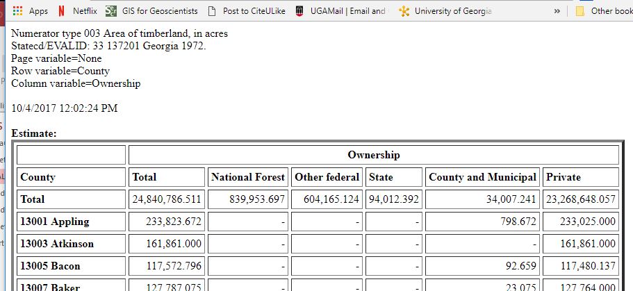
The goal for this lab is three-fold. First, this one is easy, you will learn how to submit queries against the desktop version of the EVALIDator. Second, you will explore the relationship between the volume estimate, sampling error, and the area sampled - this one requires you to think. Finally, […]
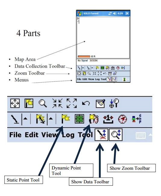
There are two components to lab 6. First you will dump your 10 Garmin GPSMAP64 GPS data points and will view them in ArcMap. After this, you will use both the Garmin and the Trimble units to map the greenspace in front of Warnell. Your deliverable for this […]
Vector Data Creation – Digitizing I Digitizing: “the art and science of connect-the-dots” (Lowe 2016) Digitizing in ArcMap is fairly simple. You: create a point, line, or polygon feature class (inside your file geodatabase) * this includes adding the appropriate fields in the attribute table load a georeferenced data source […]
I might either add topics or move a topic to Part II if we don’t cover it before the document is due. I will announce any changes during class. These are the topics I would like you to document in your notebook. You can format the instructions as a Word […]
Global Positioning System (GPS) About: The 24 satellites that make up the GPS space segment are orbiting the earth 11,000 to 12,000 miles above us. They are constantly moving, making two complete orbits in less than 24 hours. These satellites are travelling at speeds of roughly 7,000 miles an […]